Grenfell, New South Wales
| Grenfell New South Wales | |||||||||
|---|---|---|---|---|---|---|---|---|---|
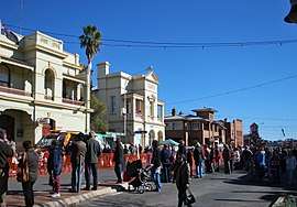 Main Street, Grenfell, during the 2011 Henry Lawson Festival | |||||||||
|
Grenfell | |||||||||
| Coordinates | 33°54′0″S 148°09′0″E / 33.90000°S 148.15000°ECoordinates: 33°54′0″S 148°09′0″E / 33.90000°S 148.15000°E | ||||||||
| Population | 2,573 (2016 census)[1] | ||||||||
| Postcode(s) | 2810 | ||||||||
| Elevation | 410 m (1,345 ft) | ||||||||
| Location |
| ||||||||
| LGA(s) | Weddin Shire | ||||||||
| State electorate(s) | Cootamundra | ||||||||
| Federal Division(s) | Hume | ||||||||
| |||||||||
Grenfell is a town in Weddin Shire in the Central West of New South Wales, Australia. It is 370 km (230 mi) west of Sydney. It is close to Forbes, Cowra and Young. At the 2011 census, Grenfell had a population of 1,996.[2] The town is served daily by connecting NSW TrainLink services from Sydney via Bathurst and Lithgow. Grenfell is approximately 5 hours from Sydney and 2 1/2 hours from Canberra.[3]
History
In 1866 shepherd, Cornelius O’Brien discovered a gold bearing quartz outcrop. Within weeks, large parties of miners from the Lambing Flats and Forbes diggings arrived. Tents, bark huts and a business centre grew along the banks of Emu Creek. A few months later, Grenfell was proclaimed on January 1, 1867 after Gold Commissioner, John Granville Grenfell, who was wounded by bushrangers near Narromine on 7 December 1866. John Granville Grenfell was driving a coach at the time and refused to stop when bushrangers called him to. He was shot twice in the groin and died 24 hours later. Between 1867 and 1869 over 1,100 kilograms (40,000 oz) of gold were produced each year on the Grenfell goldfields and were the richest gold fields in NSW during this time.
Grenfell was a goldmining town first known as Emu Creek and renamed in honour of John Grenfell, Gold Commissioner at Forbes, who had been killed in 1866 when bushrangers attacked a stagecoach on which he was travelling.[4] "Weddin" Post Office opened on 3 December 1866 and was renamed "Grenfell" on 24 December the same year.[5] By 1870-71 it was producing more gold than any other town in NSW. However, by the mid-1870s gold was in decline.
Wheat was first grown in the district in 1871. In late October 1901, the railway from Koorawatha to Grenfell was officially opened.[6] Unlike most Australian country towns Grenfell has a main street which bends.
The town's rugby league team competed for the Maher Cup.
In June 2007, the Spirit of the Bush Concert was held on the sporting fields. Acts included the organiser and Australian of the Year Lee Kernaghan, local and international star Steve Forde & the Flange, Adam Brand, Leo Sayer, Diesel, and The McClymonts.
Grenfell railway station
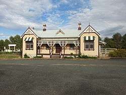
The Grenfell railway station is a heritage listed site.[7]
Attractions

- Chrysler Car Museum
- Ochre Arch Farm Tours
- Iandra Castle
- Ben Halls Cave
- Weddin Mountains National Park
- Seaton's Farm
- Bird Watching and Bird Trails
- Endemic Garden
- Wallangreen Sculpture Garden
- Grenfell Art Gallery
- Patina Gallery
- Grenfell Museum
- Historic Railway Station
- Historic Main Street and George Street
- Henry Lawson birthplace and statues
- O'Brians Hill
- The Big Gold Pick and Pan
- Sporting Hall of Fame
Major events
A full calendar of events can be found here or a list of the major events can be found below.
- Australia Day – January
- Grenfell Rodeo - March
- ANZAC Day Commemorations – April
- Grenfell Picnic Races – April
- Henry Lawson Festival of Arts – June
- Grenfell Show – August/September
- Caragabal Sheep Races – September
- Jockey Club Races – September
- Weddin Mountain Muster – September/October
- Combined Services Club Christmas Carnival - December
- Carols by Candlelight – December
Climate
| Climate data for Grenfell, New South Wales (1885-2016) | |||||||||||||
|---|---|---|---|---|---|---|---|---|---|---|---|---|---|
| Month | Jan | Feb | Mar | Apr | May | Jun | Jul | Aug | Sep | Oct | Nov | Dec | Year |
| Record high °C (°F) | 43.9 (111) |
43.1 (109.6) |
38.9 (102) |
35.3 (95.5) |
26.5 (79.7) |
23.3 (73.9) |
22.5 (72.5) |
26.5 (79.7) |
32.5 (90.5) |
35.6 (96.1) |
42.1 (107.8) |
41.0 (105.8) |
43.9 (111) |
| Average high °C (°F) | 31.8 (89.2) |
30.9 (87.6) |
27.8 (82) |
22.7 (72.9) |
17.8 (64) |
13.9 (57) |
12.9 (55.2) |
14.8 (58.6) |
18.4 (65.1) |
22.7 (72.9) |
26.7 (80.1) |
29.9 (85.8) |
22.5 (72.5) |
| Average low °C (°F) | 16.3 (61.3) |
16.1 (61) |
13.4 (56.1) |
9.3 (48.7) |
6.2 (43.2) |
4.1 (39.4) |
3.1 (37.6) |
3.9 (39) |
6.1 (43) |
8.9 (48) |
11.8 (53.2) |
14.4 (57.9) |
9.5 (49.1) |
| Record low °C (°F) | 6.0 (42.8) |
5.9 (42.6) |
3.5 (38.3) |
0.0 (32) |
−2.0 (28.4) |
−6.5 (20.3) |
−5.0 (23) |
−3.4 (25.9) |
−2.5 (27.5) |
−1.1 (30) |
2.1 (35.8) |
4.0 (39.2) |
−6.5 (20.3) |
| Average precipitation mm (inches) | 51.9 (2.043) |
48.1 (1.894) |
48.9 (1.925) |
47.0 (1.85) |
49.4 (1.945) |
58.5 (2.303) |
56.7 (2.232) |
55.7 (2.193) |
51.2 (2.016) |
54.2 (2.134) |
50.4 (1.984) |
55.0 (2.165) |
621.9 (24.484) |
| Source: Australian Bureau of Meteorology[8] | |||||||||||||
The villages of Weddin Shire
- Greenethorpe – George Greene built Iandra Castle between 1886 and 1908 and established Australia's first share farming agreement. He was instrumental in providing a rail link from Koorawatha to transport wheat. Greenethorpe grew as a support town for the rural population and was named in honour of George Greene.
- Caragabal – The town developed as a staging post and watering hole for coach drivers and horses on the run between West Wyalong and Grenfell. Caragabal was once a thriving hub for railway, stock and grain. The town has an 18-hole golf course, tennis courts, bowling club and hotel.
- Quandialla – Quandialla is the aboriginal word for spiny anteater. Founded in 1914 as a railway town, Quandialla has a population of 200 people. Services in the village include the historic hotel, general store, swimming pool, and bowling club. Quandialla was the setting for the film 1915.
Fossils
Grenfell is an important centre of for fossils of Devonian ducks, which occur in many surrounding outcrops of the Hunter Siltstone geological formation.
Notable people
- Henry Lawson, poet
- Stan McCabe, cricketer
- Reggie McNamara, cyclist
- Jan Lehane, tennis player
Education
- Grenfell Preschool & Long Day Care Centre
- Grenfell Public School
- St Joseph's Primary School - Grenfell
- Henry Lawson High School
References
- ↑ Australian Bureau of Statistics (27 June 2017). "Grenfell (State Suburb)". 2016 Census QuickStats. Retrieved 5 February 2018.

- ↑ "2011 Census QuickStats – Grenfell (Urban Centre)".
- ↑ https://www.google.com.au/maps/dir/Sydney,+New+South+Wales/Grenfell+Visitor+Information+Centre,+88+Main+St,+Grenfell+NSW+2810/@-34.1229539,149.1285379,9z/data=!3m1!4b1!4m13!4m12!1m5!1m1!1s0x6b12ae401e8b983f:0x5017d681632ccc0!2m2!1d151.2092955!2d-33.8688197!1m5!1m1!1s0x6b1a12c20c6dcda9:0x7ed23acc47233264!2m2!1d148.160622!2d-33.893456
- ↑ "Grenfell's History". Retrieved 10 April 2013.
- ↑ Premier Postal History. "Post Office List". Premier Postal Auctions. Retrieved 2011-05-26.
- ↑ "KOORAWATHA TO GRENFELL RAILWAY". The Sydney Morning Herald. National Library of Australia. 28 October 1901. p. 4. Retrieved 10 April 2013.
- ↑ "Grenfell Railway Station, New South Wales State Heritage Register (NSW SHR) Number H01155". New South Wales State Heritage Register. Office of Environment and Heritage. Retrieved 18 May 2018.
- ↑ "Climate statistics for Grenfell". Australian Bureau of Meteorology. Retrieved 6 October 2016.
External links
![]()