Gregoire Lake Provincial Park
| Gregoire Lake Provincial Park | |
|---|---|
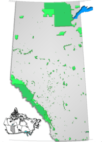
 Location of Gregoire Lake Provincial Park in Alberta | |
| Location | Wood Buffalo, Alberta, Canada |
| Nearest city | Fort McMurray |
| Coordinates | 56°29′06″N 111°10′58″W / 56.48500°N 111.18278°WCoordinates: 56°29′06″N 111°10′58″W / 56.48500°N 111.18278°W |
| Area | 1,720.28 acres (6.9617 km2) |
| Established | October 21, 1969 |
| Governing body | Alberta Tourism, Parks and Recreation |
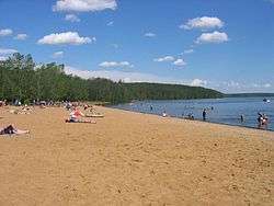
View of Gregoire Lake located by the Park
Gregoire Lake Provincial Park is a provincial park in Alberta, Canada. It is located close to Highway 63, between Fort McMurray and Lac La Biche, on the northern shore of Gregoire Lake.
The park is situated at an elevation of 490 m (1,610 ft) and has a surface of 27.2 km2 (10.5 sq mi). It was established on October 21, 1969 and is maintained by Alberta Tourism, Parks and Recreation.
Amenities
The park has one overnight camping ground on the shore of Gregoire Lake and an additional day use area.
Activities
The following activities are available in the park:[1]
- Beach activities
- Birdwatching
- Camping
- Canoeing/kayaking
- Cross-country skiing (10 km non-groomed trails)
- Fishing
- Group camping
- Front Country Hiking
- Horseshoes
- Ice fishing
- Power boating
- Sailing
- Snowmobiling (on to lake only and on designated snowmobile trails outside the park)
- Swimming
- Water-skiing
- Windsurfing
See also
References
- ↑ Alberta Tourism, Parks, Recreation & Culture. "Activities in Gregoire Lake Provincial Park". Retrieved 2008-09-13.
External links
- Alberta Tourism, Parks, Recreation & Culture. "Gregoire Lake Provincial Park". Retrieved 2008-09-13.
This article is issued from
Wikipedia.
The text is licensed under Creative Commons - Attribution - Sharealike.
Additional terms may apply for the media files.