Greenleaf, Minnesota
| Greenleaf, Minnesota | |
|---|---|
| Unincorporated community | |
 Greenleaf, Minnesota Location of the community of Greenleaf within Meeker County  Greenleaf, Minnesota Greenleaf, Minnesota (the US) | |
| Coordinates: 44°59′47″N 94°29′58″W / 44.99639°N 94.49944°WCoordinates: 44°59′47″N 94°29′58″W / 44.99639°N 94.49944°W | |
| Country | United States |
| State | Minnesota |
| County | Meeker |
| Township | Ellsworth Township and Greenleaf Township |
| Elevation | 1,112 ft (339 m) |
| Time zone | UTC-6 (Central (CST)) |
| • Summer (DST) | UTC-5 (CDT) |
| ZIP code | 55355 |
| Area code(s) | 320 |
| GNIS feature ID | 644445[1] |
Greenleaf is an unincorporated community in Meeker County, Minnesota, United States, near Litchfield and Cedar Mills. The community is located along Meeker County Road 18 near State Highway 22 (MN 22).
Greenleaf is located within Ellsworth Township and Greenleaf Township.
| Historical population | |||
|---|---|---|---|
| Census | Pop. | %± | |
| 1870 | 54 | — | |
| U.S. Decennial Census[2] | |||
History
Greenleaf was platted in 1859 by William Henry Greenleaf, and named for him.[3] A post office was established at Greenleaf in 1860, and remained in operation until it was discontinued in 1906.[4]
References
- ↑ "Greenleaf, Minnesota". Geographic Names Information System. United States Geological Survey.
- ↑ United States Census Bureau. "Census of Population and Housing".
- ↑ Upham, Warren (1920). Minnesota Geographic Names: Their Origin and Historic Significance. Minnesota Historical Society. p. 339.
- ↑ "Meeker County". Jim Forte Postal History. Retrieved 21 July 2015.
Municipalities and communities of Meeker County, Minnesota, United States | ||
|---|---|---|
| Cities | 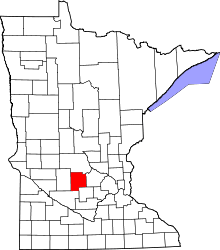 | |
| Townships | ||
| Unincorporated communities | ||
| Footnotes | ‡This populated place also has portions in an adjacent county or counties | |
This article is issued from
Wikipedia.
The text is licensed under Creative Commons - Attribution - Sharealike.
Additional terms may apply for the media files.