Great Lake (Tasmania)
| Great Lake | |
|---|---|
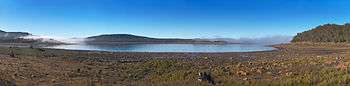 The northern end of the Great Lake | |
|
Map showing the Great Lake in Tasmania | |
| Location | Central Northern Tasmania |
| Coordinates | 41°52′S 146°45′E / 41.867°S 146.750°ECoordinates: 41°52′S 146°45′E / 41.867°S 146.750°E |
| Type | Natural lake; reservoir |
| Primary inflows |
|
| Primary outflows | Shannon River |
| Catchment area | 399 square kilometres (154 sq mi)[1] |
| Basin countries | Australia |
| Built | 1967 |
| Max. length | 24.6 km (15.3 mi) |
| Max. width | 12 km (7.5 mi) |
| Surface area | 176 km2 (68 sq mi)[1] |
| Surface elevation | 1,030 m (3,380 ft) AHD |
| Frozen | During some winters. |
| Islands | Reynolds; Howells Neck; Pine; Helen; Kangaroo; and Maclanachans Point |
| Settlements | Miena, Breona, Liaweenee |
| References | [1] |
The Great Lake is a natural lake and man-made reservoir that is located in the central northern region of Tasmania, Australia.
Location and features
Fed by the Pine Rivulet and Breton Rivulet, the original natural freshwater lake, much smaller in size than its current 176-square-kilometre (68 sq mi) surface area, was expanded as a result of the 1922 construction of Miena Dam #2 at its southern outflow into the Shannon River. This dam is considered to be of high heritage value by Engineers Australia.[2]
Miena Dam #2 created the once-famous Shannon Rise,[3] in the 500-metre section of the Shannon River between the dam and Shannon Lagoon. The hatching of thousands of caddis moths in early summer, attracted large numbers of trout and fishermen.
In 1967, a sloping-core rock-fill dam was built just downstream of Miena Dam #2 to increase the maximum-capacity level, destroying the Shannon Rise. It was raised a further six metres (twenty feet) in 1982,[4] causing Miena Dam #2 to be periodically submerged.
After Lake Pedder, the Great Lake is the state's third largest freshwater lake.[1]
At 1,030 metres (3,380 ft) above sea level, the lake's uses include hydro-electric power, fishing, and tourism. Water from the lake flows into Poatina Power Station to generate hydro-electric power.[5]
The nearby towns of Liaweenee and Miena are popular holiday shack destinations for local tourists, despite the area's reputation as being one of the coldest places in the generally mild-weathered state. During the winter months, when the weather is hardly conducive to camping, the population of these two small towns drops to two or three hundred. Parts of the lake surface have frozen during July in some years.
The Lake Highway or Highland Lakes Road runs along the west side of the lake and is sometimes snowed under in winter.
See also
References
- 1 2 3 4 "Register of Large Dams in Australia" (Excel (requires download)). Dams information. Australian National Committee on Large Dams. 2010. Retrieved 23 June 2015.
- ↑ "Miena Dam No. 2" (PDF). Heritage Markers. Engineers Australia. January 2007. Retrieved 1 June 2018.
- ↑ "Fly Fishing in Tasmania". Australian Fly Fishing Museum. 2018. Retrieved 1 June 2018.
- ↑ "Great Lake: Anglers Access" (PDF). Inland Fisheries Service (4 ed.). Government of Tasmania. n.d. Retrieved 1 June 2018.
- ↑ "Poatina Power Station Fact Sheet" (PDF). Our power stations: Great Lake - South Esk. Hydro Tasmania. Retrieved 23 June 2015.
Further reading
- Jetson, Tim (1989) The roof of Tasmania : a history of the Central Plateau. Launceston, Tas. : Pelion Press. ISBN 0-7316-7214-3
- Tasmania. Hydro-Electric Commission (1925), The hydro-electric power of Tasmania : a description of the Great Lake Hydro-Electric Development and of the Tasmanian Electricity Supply System Published under authority, Hydro-Electric Department of Tasmania, Tait, Melbourne