Great Bridge North railway station
- Not to be confused with the nearby Great Bridge South railway station.
| Great Bridge North | |
|---|---|
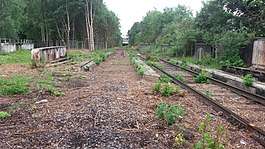 Great Bridge North station site, being lifted in preparation for the metro extension and soon for freight traffic | |
| Location | |
| Place | Great Bridge |
| Area | Sandwell |
| Coordinates | 52°31′59″N 2°02′08″W / 52.5331°N 2.0356°WCoordinates: 52°31′59″N 2°02′08″W / 52.5331°N 2.0356°W |
| Grid reference | SO976927 |
| Operations | |
| Original company | South Staffordshire Railway |
| Pre-grouping | London and North Western Railway |
| Post-grouping | London, Midland and Scottish Railway |
| Platforms | 2 (3) |
| History | |
| 1850 | Opened as Great Bridge[1] |
| 1950 | Renamed Great Bridge North'[1] |
| 1964 | Closed to passengers |
| 1972 | Closed outright |
| Disused railway stations in the United Kingdom | |
|
Closed railway stations in Britain A B C D–F G H–J K–L M–O P–R S T–V W–Z | |
|
| |
Great Bridge North railway station was a station on the South Staffordshire Line in England.
History
The station was built in 1850 and served by the South Staffordshire Railway, which was later absorbed by the London and North Western Railway) which in 1923 amalgamated with several other railways to create the London, Midland and Scottish Railway (the station shared the name Great Bridge with its Great Western Railway counterpart built in 1866). North was appended to the name of the station just after nationalisation.
Passenger usage declined in the early 1880s, and the line became mainly freight in 1887. It remained open for goods traffic as the district became highly industrialised in the heyday of the Black Country's industrial past. Local industry declined after World War II and road transport became more common. British Rail closed the station to passengers through the Beeching Axe in 1964, but it continued as a freight station for local factories until 1972. Goods trains continued to pass through the site of the station until 1993. By that date no sign of the station or the goods yard remained. It is now derelict and mostly fenced off.
Midland Metro
A £1,100,000/15-year-long regeneration project is expected to re-open the closed section of railway through Dudley[2] as a combined Midland Metro tramway with a separate heavy rail line for goods trains. The old station site is earmarked as the location of a Midland Metro stop on the local tram network's second line between Walsall, Dudley Port railway station, Dudley railway station and the Merry Hill Shopping Centre scheduled for opening upon completion in 2011.SDIT[3] The freighters would continue on past Brettell Lane railway station and on to the mainline at Stourbridge junction.[4]
Gallery
 Great Bridge North looking down from the crossing and past the signal box, 2003
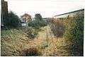 Great Bridge North station, 2003
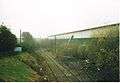 Great Bridge North station, 2005
 Great Bridge North signal box, 2001.
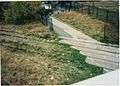 Great Bridge North's road crossing by the signal box, 2003.
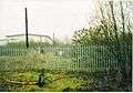 Great Bridge North railway station, walking down from the crossing and past the signal box, towards the modern warehouse in 2003. The canal bridge is fenced off and collapsing.
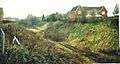 The former siding and platform entrance outside Great Bridge North station, 2011
See also
West Midlands Metro Line 2 | |||||||||||||||||||||||||||||||||||||||||||||||||||||||||||||||||||||||||||||||||||||||||||||||||||||||||||||||||||||||||||||||||||||||||||||||||||||||||||||||||||||||||||||||||||||||||||||||||||||||||||||||
|---|---|---|---|---|---|---|---|---|---|---|---|---|---|---|---|---|---|---|---|---|---|---|---|---|---|---|---|---|---|---|---|---|---|---|---|---|---|---|---|---|---|---|---|---|---|---|---|---|---|---|---|---|---|---|---|---|---|---|---|---|---|---|---|---|---|---|---|---|---|---|---|---|---|---|---|---|---|---|---|---|---|---|---|---|---|---|---|---|---|---|---|---|---|---|---|---|---|---|---|---|---|---|---|---|---|---|---|---|---|---|---|---|---|---|---|---|---|---|---|---|---|---|---|---|---|---|---|---|---|---|---|---|---|---|---|---|---|---|---|---|---|---|---|---|---|---|---|---|---|---|---|---|---|---|---|---|---|---|---|---|---|---|---|---|---|---|---|---|---|---|---|---|---|---|---|---|---|---|---|---|---|---|---|---|---|---|---|---|---|---|---|---|---|---|---|---|---|---|---|---|---|---|---|---|---|---|---|
Wednesbury-to-Brierley-Hill-extension | |||||||||||||||||||||||||||||||||||||||||||||||||||||||||||||||||||||||||||||||||||||||||||||||||||||||||||||||||||||||||||||||||||||||||||||||||||||||||||||||||||||||||||||||||||||||||||||||||||||||||||||||
| |||||||||||||||||||||||||||||||||||||||||||||||||||||||||||||||||||||||||||||||||||||||||||||||||||||||||||||||||||||||||||||||||||||||||||||||||||||||||||||||||||||||||||||||||||||||||||||||||||||||||||||||
| Preceding station | Disused railways | Following station | ||
|---|---|---|---|---|
| Wednesbury Town | South Staffordshire Railway Later LNWR, then LMS, finally BR South Staffs Line (1850-1964) |
Dudley Port | ||
| Walsall or Terminus |
BR, then Freightliner South Staffs Line (inc. Dudley-Stourbridge Junction to 1962) (1852-1964) |
Dudley Freightliner Terminal | ||
References
- 1 2 "Great Bridge North Station". Rail Around Birmingham and the West Midlands. Retrieved 31 March 2017.
- ↑ http://www.centro.org.uk/Metro/Nov%2003/W-B%20Timetable.asp
- ↑ "Archived copy". Archived from the original on 2012-09-28. Retrieved 2012-11-19.
- ↑ "Archived copy". Archived from the original on 2012-09-28. Retrieved 2012-11-19.