Grande Terre (New Caledonia)
Grande Terre is the largest and principal island of New Caledonia.
British explorer James Cook sighted Grande Terre in 1774 and named it "New Caledonia", Caledonia being a Latin name for parts of northern Scotland. Eventually, the name "New Caledonia" became applied to Grande Terre and its surrounding islands.
The largest settlement on Grande Terre is Nouméa, the capital city of New Caledonia. Locals refer to Grand Terre as "Le Caillou", the rock.[1]
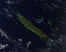
Grande Terre is oriented northwest-to-southeast; its area is 16,372 square kilometres (6,321 square miles). It is nearly 400 kilometres (250 miles) in length and 50–70 km (30–40 mi) wide in most places. A mountain range runs the length of the island, with five peaks over 1,500 metres (4,900 feet). The highest point is Mont Panié at 1,628 m (5,341 ft) elevation.
Notes
- ↑ South Pacific handbook - David Stanley, p. 549, at Google Books