Gräfelfing
| Gräfelfing | ||
|---|---|---|
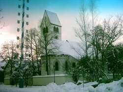 Saint Stephan Church | ||
| ||
 Gräfelfing Location of Gräfelfing within Munich district 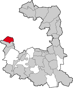 | ||
| Coordinates: 48°7′8″N 11°25′44″E / 48.11889°N 11.42889°ECoordinates: 48°7′8″N 11°25′44″E / 48.11889°N 11.42889°E | ||
| Country | Germany | |
| State | Bavaria | |
| Admin. region | Oberbayern | |
| District | Munich | |
| Government | ||
| • Mayor | Christoph Göbel (CSU) | |
| Area | ||
| • Total | 9.58 km2 (3.70 sq mi) | |
| Elevation | 540 m (1,770 ft) | |
| Population (2017-12-31)[1] | ||
| • Total | 13,803 | |
| • Density | 1,400/km2 (3,700/sq mi) | |
| Time zone | CET/CEST (UTC+1/+2) | |
| Postal codes | 82166 | |
| Dialling codes | 089 | |
| Vehicle registration | M | |
| Website | www.graefelfing.de | |

Gräfelfing is a municipality in the district of Munich, in Bavaria, Germany. It is located 1 km west of Munich (centre). The name "Gräfelfing" first appears as "Grevolvinga", which as per one hypothesis could possibly name a tribe leader named "grey wolf" ("*Grevol" -> German "grau(er)" -> English "grey"; "*vinga" -> German "Wolf" -> English "wolf").
Gräfelfing is ranked 5th of the wealthiest municipalities in Germany (2005).
Official Site: Gräfelfing
References
- ↑ "Fortschreibung des Bevölkerungsstandes". Bayerisches Landesamt für Statistik und Datenverarbeitung (in German). September 2018.
This article is issued from
Wikipedia.
The text is licensed under Creative Commons - Attribution - Sharealike.
Additional terms may apply for the media files.