Gose Khurd Dam
| Gose Khurd Dam | |
|---|---|
 Gose Khurd Dam | |
 Location of Gose Khurd Dam in Maharashtra | |
| Official name | Gosikhurd Dam D03002 |
| Location | Pauni, Bhandara district, Maharashtra, India |
| Coordinates | 20°52′26″N 79°36′29″E / 20.8738154°N 79.6081781°ECoordinates: 20°52′26″N 79°36′29″E / 20.8738154°N 79.6081781°E |
| Owner(s) | Government of Maharashtra, India |
| Dam and spillways | |
| Type of dam | Earthfill |
| Impounds | Wainganga River |
| Height | 22.5 m (74 ft) |
| Length | 1,135 m (3,724 ft) |
| Dam volume | 3.83×10⁶ m3 (5,010,000 cu yd) |
| Spillway capacity | 67,000 m3/s (2,400,000 cu ft/s) |
| Reservoir | |
| Creates | Gosikhurd |
| Total capacity | 1.15×10⁹ m3 (930,000 acre⋅ft) |
| Active capacity | 740.20×10⁶ m3 (600,090 acre⋅ft) |
| Catchment area | 34,862 km2 (13,460 sq mi) |
| Surface area | 222 km2 (86 sq mi) |
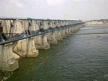
Gose Khurd Dam, (Marathi: गोसे खुर्द धरण) is an earthfill dam on the Wainganga River near Pauni in Bhandara district in state of Maharashtra in India.[1] The dam consists of 33 Nos of spillway gates to regulate irrigation water into the river throughout the year.
The height of the dam above lowest foundation is 22.5 m (74 ft) while the length is 1,135 m (3,724 ft). The dam volume content is 3.83 million m3 and gross water storage capacity is 1,146 million m3. Its purpose is irrigation.[2]
See also
References
- ↑ "Gosikhurd Dam D03002". Retrieved 5 March 2016.
- ↑ Specifications of large dams in India Archived 2011-07-21 at the Wayback Machine. See Project Identification Code MH09HH1817.
This article is issued from
Wikipedia.
The text is licensed under Creative Commons - Attribution - Sharealike.
Additional terms may apply for the media files.