Gortineddan
Gortineddan is a townland in the Civil Parish of Tomregan, Barony of Knockninny, County Fermanagh, Northern Ireland.
Etymology
The townland name is an anglicisation of the Gaelic placename “Gort an Fheadáin” which means ‘The Field of the Stream’. The oldest surviving mention of the name is in the Annals of Ulster under the year 1450 AD when Donnchadh Maguire murdered Cathal Maguire, son of Thomas, Chief of the Maguires, at Gort-an-Fhedáin. The same Annals also note a battle at Gort-an-Fhedain in the year 1457 between Chief Thomas Maguire and Lochlann O’Rourke. The townland lies on the border with Cavan and the road south runs through it so it features in a lot of border incidents throughout history. The townland is later mentioned in a grant dated 14 October 1612 where it is spelled ‘Gortmeddan’. Spellings in later grants are 1620- Gortmedan, 1659 – Gortened.[1] Ambrose Leet's 1814 Directory spells the name as Gort-neden.[2].
Geography
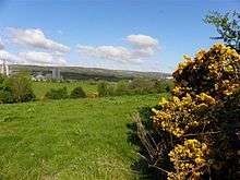
It is bounded on the north by Ummera townland, on the east by Drumderg and Kiltycrose townlands, on the south by Carickaleese and Knockadoois townlands and on the west by Gortmullan townland and by the international border with County Cavan and the Republic of Ireland. Its chief geographical features are the Duvoge River, Oak Wood and a drumlin hill reaching to 70 metres above sea-level. The townland is traversed by the B127 Border Road to Ballyconnell and some minor lanes. Gortineddan covers an area of 255 statute acres.
History
The townland formed part of the ballybethagh of Calvagh in medieval times. At the beginning of the 17th century it was owned jointly by Bryan McPhilip O’Reyly and Edward Rutlidge but was confiscated by the Crown in the 1609 Ulster Plantation and it formed part of the half-territory of Aughrin which was granted to Sir Hugh Culme in 1610. Culme later relinquished his claim to the Crown, perhaps because there was confusion at the time as to whether the townland formed part of County Fermanagh or County Cavan. By an order of the Lord Deputy dated 14 October 1612 the townland was granted, inter alia, to Lady Margaret O’Neill, the widow of Sir Hugh Maguire deceased. In 1641 and also in 1670 it was owned by Sir William Balfour (general).[3]
The Tithe Applotment Books for 1827 list the following tithepayers in the townland- McGee, Bennet, Theackle, Donahy, Elliott, Whittendale, Reilly, McKiernan, Montgomery.[4]
In 1829 a Sunday school was kept in the townland, funded by the Hibernian Sunday School Society.[5]
In 1841 the population of the townland was 123, being 60 males and 63 females. There were twenty-eight houses in the townland, two of which were uninhabited.[6]
In 1851 the population of the townland was 103, being 47 males and 56 females, the reduction being due to the Great Famine (Ireland). There were twenty houses in the townland, one of which was uninhabited.[7]
Griffith's Valuation of 1857 lists twenty-three occupiers in the townland.[8]
In 1861 the population of the townland was 88, being 45 males and 43 females. There were nineteen houses in the townland, of which one was uninhabited.[9]
In 1871 the population of the townland was 66, being 34 males and 32 females. There were fifteen houses in the townland and all were inhabited.(page 606 of census)[10]
In 1881 the population of the townland was 59, being 28 males and 31 females. There were twelve houses in the townland, all were inhabited.[11]
In 1891 the population of the townland was 62, being 36 males and 26 females. There were twelve houses in the townland, of which two were uninhabited.[12]
In the 1901 census of Ireland, there are thirteen families listed in the townland.[13]
In the 1911 census of Ireland, there are fourteen families listed in the townland.[14]
Antiquities
The historic sites in the townland are a medieval ringfort, the international border crossing with the Republic of Ireland and the ruins of Oakhill and Oakwood schoolhouses.
References
External links