Goring & Streatley railway station
| Goring & Streatley | |
|---|---|
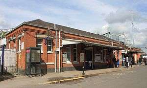
 The station with the new footbridge and electrification in progress | |
| Location | |
| Place | Goring-on-Thames |
| Local authority | District of South Oxfordshire |
| Grid reference | SU602806 |
| Operations | |
| Station code | GOR |
| Managed by | Great Western Railway |
| Number of platforms | 4 |
| DfT category | E |
|
Live arrivals/departures, station information and onward connections from National Rail Enquiries | |
| Annual rail passenger usage* | |
| 2012/13 |
|
| 2013/14 |
|
| 2014/15 |
|
| 2015/16 |
|
| 2016/17 |
|
| History | |
| Key dates | Opened 1 June 1840 |
| Original company | Great Western Railway |
| Pre-grouping | Great Western Railway |
| Post-grouping | Great Western Railway |
| 1 June 1840 | GWR Reading to Steventon opened |
| 1 June 1840 | Opened as Goring |
| 9 November 1895 | Renamed Goring & Streatley |
| National Rail – UK railway stations | |
| * Annual estimated passenger usage based on sales of tickets in stated financial year(s) which end or originate at Goring & Streatley from Office of Rail and Road statistics. Methodology may vary year on year. | |
|
| |
Goring & Streatley railway station is on the Great Western Main Line serving the twin villages of Goring-on-Thames, Oxfordshire and Streatley, Berkshire in England. The station is in Goring-on-Thames, adjacent to the village centre and some five minutes walk from Goring and Streatley Bridge, which connects the village with Streatley, across the River Thames. It is 44 miles 60 chains (72.0 km) down the line from London Paddington and is situated between Pangbourne to the east and Cholsey to the west. It is served by local services operated by Great Western Railway (GWR).
The station has two side platforms (platform 1 on the down main line and platform 4 on the up relief line) and a central island platform with two faces (platform 2 on the up main line and platform 3 on the down relief line).[1] Platforms 1 and 2 are only used when engineering works cause stopping trains to use the fast tracks, and the platform edges are closed off by fences incorporating normally closed and locked gates.
The main station building is to the east of the station, alongside platform 4 and on the opposite side of the station to the village centre. There is a large car park to the south of the station building. There are also two pedestrian entrances onto platform 1, one of which links directly to Goring village centre. Access between the platforms is via a footbridge, accessed by steps and lifts from all platforms.
History
The station was on the original line of the Great Western Railway, on the section between Reading and Steventon that opened on 1 June 1840. Originally named Goring, the station was located between Pangbourne and Moulsford stations. In 1892, Moulsford station was closed and replaced by the current Cholsey station. Goring station was renamed Goring & Streatley on 9 November 1895 to prevent confusion with Goring-By-Sea.[2][3][4]
Preparation for the electrification of the line between Paddington and Bristol/Oxford required raised clearances and hence the replacement of the old footbridge. Following a strong local campaign led by the mobility group MIGGS (Mobility Issues Group for Goring and Streatley), Network Rail added lifts to the new footbridge, which was opened in June 2016. These changes also resulted in the demolition of the old ladies waiting room and toilet block on the island platform.
Services
Goring & Streatley station is served by stopping services run by GWR between London Paddington and Didcot Parkway. The typical off-peak service from the station is every 30 minutes in each direction with an hourly service on Sundays. There are also additional services during morning and evening peak hours on weekdays between Reading and Oxford.
Typical journey times are approximately 15 minutes to Didcot Parkway and Reading, 20 minutes to Oxford, and approximately 1 hour 15 minutes to London Paddington.[5]
| Preceding station | Following station | |||
|---|---|---|---|---|
| Cholsey | Great Western Railway Commuter services Great Western Main Line |
Pangbourne | ||
| Historical railways | ||||
| Moulsford Line open, station closed |
Great Western Railway Great Western Main Line |
Pangbourne Line and station open | ||
Gallery
 Main entrance to Goring & Streatley station
 The old footbridge and stairs on platform 4; bridge and stairs since demolished
 The temporary footbridge used between demolition of old and build of new
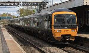 A GWR service to London at platform 4
 The little-used platform 1, showing fencing off of platforms 1 and 2
References
- ↑ Yonge, John; Padgett, David (August 2010) [1989]. Bridge, Mike, ed. Railway Track Diagrams 3: Western (5th ed.). Bradford on Avon: Trackmaps. map 3C. ISBN 978-0-9549866-6-7.
- ↑ MacDermot, E.T. (1927). "Chapter IV Construction". History of the Great Western Railway. 1 (1st ed.). Paddington: Great Western Railway. p. 102.
- ↑ Mitchell, Vic; Smith, Keith (March 2002). "Figure 53". Reading to Didcot. Western Main Lines. Midhurst: Middleton Press. ISBN 1-901706-79-6.
- ↑ Butt, R.V.J. (1995). The Directory of Railway Stations. Yeovil: Patrick Stephens Ltd. pp. 165, 240. ISBN 1-85260-508-1. R508.
- ↑ https://www.gwr.com/~/media/gwr/pdfs/timetables/2018/amended-june/t10,-d-,web-v2.pdf?la=en
Bibliography
| Wikimedia Commons has media related to Goring and Streatley railway station. |
- Butt, R. V. J. (1995). The Directory of Railway Stations: details every public and private passenger station, halt, platform and stopping place, past and present (1st ed.). Sparkford: Patrick Stephens Ltd. ISBN 978-1-85260-508-7. OCLC 60251199.
- Jowett, Alan (March 1989). Jowett's Railway Atlas of Great Britain and Ireland: From Pre-Grouping to the Present Day (1st ed.). Sparkford: Patrick Stephens Ltd. ISBN 978-1-85260-086-0. OCLC 22311137.
Coordinates: 51°31′19.20″N 1°08′0.60″W / 51.5220000°N 1.1335000°W