Goodway, Alabama
| Goodway, Alabama | |
|---|---|
| Unincorporated community | |
 Goodway, Alabama  Goodway, Alabama | |
| Coordinates: 31°20′13″N 87°25′33″W / 31.33694°N 87.42583°WCoordinates: 31°20′13″N 87°25′33″W / 31.33694°N 87.42583°W | |
| Country | United States |
| State | Alabama |
| County | Monroe |
| Elevation | 381 ft (116 m) |
| Time zone | UTC-6 (Central (CST)) |
| • Summer (DST) | UTC-5 (CDT) |
| ZIP code | 36449 |
| Area code(s) | 251 |
| GNIS feature ID | 119153[1] |
Goodway is an unincorporated community in Monroe County, Alabama, United States. Goodway is located along the Alabama and Gulf Coast Railway, 6.8 miles (10.9 km) south of Frisco City. Goodway had a post office until it closed on December 31, 1988; it still has its own ZIP code, 36449.[2][3]
References
- ↑ "Goodway". Geographic Names Information System. United States Geological Survey.
- ↑ United States Postal Service (2012). "USPS - Look Up a ZIP Code". Retrieved 2012-02-15.
- ↑ "Postmaster Finder - Post Offices by ZIP Code". United States Postal Service. Retrieved January 11, 2013.
Municipalities and communities of Monroe County, Alabama, United States | ||
|---|---|---|
| City | 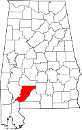 | |
| Towns | ||
| CDPs | ||
| Unincorporated communities | ||
| Ghost town | ||
This article is issued from
Wikipedia.
The text is licensed under Creative Commons - Attribution - Sharealike.
Additional terms may apply for the media files.