Golden Bay
| Golden Bay / Mohua | |
| Bay | |
 Landsat image | |
| Country | New Zealand |
|---|---|
| Coordinates | 40°40′S 172°50′E / 40.667°S 172.833°ECoordinates: 40°40′S 172°50′E / 40.667°S 172.833°E |
 Golden Bay | |
Golden Bay / Mohua is a shallow, paraboloid shaped bay in New Zealand, near the northern tip of the South Island. An arm of the Tasman Sea, the bay lies northwest of Tasman Bay and Cook Strait. It is protected in the north by Farewell Spit, a 26 km long arm of fine golden sand which is the country's longest sandspit. The Aorere and Takaka Rivers flow into the bay from the south.
It is located in the Tasman Region, one of the territorial authorities of New Zealand.
The bay was once a resting area for migrating whales and dolphins such as southern right whales[1] and humpback whales, and pygmy blue whales may be observed off the bay as well.[2]
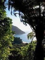
The west and northern regions of the bay are largely unpopulated. Along its southern coast are the towns of Takaka and Collingwood, and also the Abel Tasman National Park. Separation Point, the natural boundary between Golden and Tasman Bays is situated within the park. Basal part of the spit approaches to the North West Nelson National Park.
It is known for being a popular tourist destination, because of its good weather and relaxed, friendly lifestyle. Its beaches like Tata Beach are popular locations for retirees and holiday-homes.
History
Māori lived along the shores of Golden Bay from at least 1450, which is the earliest dated archaeological evidence (from carbon dating) yet found. In 2010 an extensive scientific study was made of Golden Bay by a team from Otago University led by Ian Barber. They accurately plotted and investigated a large number of early Māori sites ranging from pā to kāinga to probable kumara gardens that stretch along the coastal arc from the base of Farewell Spit at Triangle Flat, 60 km eastwards to a pā site 10 km east of Separation Point.
The iwi who occupied this area in 1642 were the Ngāti Tūmatakōkiri from the North Island.
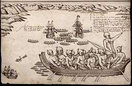
Dutch explorer Abel Tasman anchored in this bay in 1642. Ngāti Tūmatakōkiri rammed the Dutch ship's cockboat with a waka and four Dutch seamen were killed by Māori, prompting Tasman to name it Moordenaar's Bay (Murderers Bay). Archeological research has shown the Dutch had tried to land at a major agricultural area, which the Māori may have been trying to protect.[3] Barber postulated that the iwi may have been insecure in their control of the bay and its resources because of their own relatively recent arrival.
Little is known of the history of Ngāti Tūmatakōkiri people as they were extinguished by a Māori invasion during the Musket Wars about 1823.[4][5]
In 1642 Tasman saw at least 22 waka. He recorded that of the 11 waka that chased his ship, most had 17 men on board. This gives a total of about 200 men, with a likely population of about 500 people. Tasman had already been in the bay five days when attacked giving the Māori time to assemble an attack force.
Archaeological evidence has not shown any large settlements so it is likely that the iwi normally lived in whanau based groups scattered along the coast but mainly in the eastern bay at Ligar Beach, Tata Beach and Wainui Bay where there are 20 known archaeological sites in a 10 km zone.
In 1770, during his first voyage, English explorer James Cook included the bay as part of Blind Bay, but upon his second voyage to the bay in 1773 realised that it was in fact the location of Murderers Bay. The French explorer Jules Dumont d'Urville appears to have changed the name to Massacre Bay.
European settlement commenced in October 1842 with the Lovell family settling at Motupipi near the then existing Māori pa site. Prior to the Lovell's settling, in March of that year a Mr Tuckett had discovered coal on the beach near the Motupipi pa.[6] There was a report from May 1841, which also stated there was coal in the area.[7] In the 1840s, following the discoveries, the local population unsuccessfully sought to have it renamed Coal Bay.[8] Then, in the late 1850s, with the discovery of gold in at Aorere, its name was changed to Golden Bay.[9][10] In the Great Depression, miners returned to search for any remaining gold in a government-subsidised prospecting scheme for the unemployed, and about 40 miners lived in a dozen huts around Waingaro Forks.[11]
In December 2011 the bay, as well as much of the Nelson/Tasman region, was hit by heavy rain and flooding. This affected many homes around the Pohara/Ligar Bay/Tata Beach/Wainui area. The road to Totaranui, a popular isolated tourist destination in Tasman Bay, was badly damaged and was reopened on 29 June 2012.
In August 2014, the name of the bay was officially altered to Golden Bay / Mohua.[12]
 Golden Bay and Farewell Spit from the sky |
 One of many beaches in Abel Tasman National Park |
References
- ↑ http://www.stuff.co.nz/nelson-mail/news/8918/Sighting-of-rare-whale
- ↑ Torres G. L.. 2013. Evidence for an unrecognised blue whale foraging ground in New Zealand. New Zealand Journal of Marine and Freshwater Research 47(2). ResearchGate. Retrieved on 3 March 2017
- ↑ "First contact violence linked to food". New Zealand Herald. 23 September 2010. Retrieved 23 September 2010.
- ↑ Musket Wars R. Crosby p 21.
- ↑ Current Anthropology. Vol 53, No 6. Dec 2012. Garden of Rongo. I Barber. University of Otago.
- ↑ Discovery of coal and freestone, Nelson Examiner and New Zealand Chronicle, Volume I, Issue 4, 2 April 1842, Page 15
- ↑ Commercial prospects of New Zealand, New Zealand Gazette and Wellington Spectator, Volume II, Issue 59, 29 May 1841, Page 3
- ↑ Auckland Extracts, Nelson Examiner and New Zealand Chronicle, Volume VI, Issue 287, 4 September 1847, Page 105
- ↑ McLintock, A. H.; George William Grindley (1966). "Golden Bay". Te Ara. Retrieved 14 September 2010.
- ↑ Advertisements, Colonist, Volume II, Issue 172, 14 June 1859, Page 2
- ↑ White, Rebekah (July–August 2018). "Waingaro Forks Hut". New Zealand Geographic (152): 21.
- ↑ "NZGB decisions". Land Information New Zealand. August 2014. Archived from the original on 21 November 2015. Retrieved 7 November 2015.