Goldbach (Bode)
| Goldbach | |
|---|---|
 One source of the Goldbach | |
| Location |
Saxony-Anhalt, |
| Reference no. | DE: 56852 |
| Physical characteristics | |
| Main source |
east of Hartenberg fell near Elbingerode c. 516 m above sea level (NHN) 51°47′31″N 10°49′49″E / 51.79200130°N 10.83041660°ECoordinates: 51°47′31″N 10°49′49″E / 51.79200130°N 10.83041660°E |
| River mouth |
in Wegeleben into River Bode 51°53′20″N 11°10′59″E / 51.8888389°N 11.1831861°E |
| Length | 34 km [1][2] |
| Basin features | |
| Progression | Bode→ Saale→ Elbe→ North Sea |
| Basin size | 101 km² [1] |
The Goldbach is a left tributary of the River Bode, about 30 kilometres (19 mi) long, in the Harz Mountains of Germany.
Course
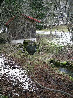
The Goldbach rises east of the uplands of Elbingerode. There are three major headwaters. The longer one, tradidionally called Teufelsbach (Devil's Beck) is defined as the upper course, hydrographically. The other one, starting from a spring called Eggeröder Brunnen, traditionally is called Klostergrundbach (Covent Dale Beck) or Goldbach. The third major headwater is the Silberborn or Mönchsbach in Silberborn Valley, passing beneath Michaelstein Abbey. Their confluence is near Mönchemühle (Monks' Mill) in Blankenburg. In spring, the headwaters of the Goldbach can become raging meltwater torrents.
The stream passes under the B 6 federal highway and is joined by some other streams. In the forelands of Harz Mountains, it passes Langenstein and flows below the Spiegelsberge hills through the southern outskirts of Halberstadt. Than it passes through the center of Harsleben and reaches Wegeleben, where it discharges into River Bode.
Fauna
Numerous endangered species live in the Goldbach, such as the brown trout and small shellfish.
Tributaries
- Molkegraben (right)
- Sauteichsgraben (left)
References
- 1 2 Sachsen-Anhalt-Viewer with theme "Gewässer" and area measuring
- ↑ GPS track, drawn according to Sachsen-Anhalt-Viewer
External links
- The Goldbach in the Harz (in German)