Glenville, Kentucky
| Glenville | |
|---|---|
| Unincorporated community | |
| Nickname(s): Lickskillet | |
 Glenville Location within the state of Kentucky  Glenville Glenville (the US) | |
| Coordinates: 37°35′40″N 87°11′36″W / 37.59444°N 87.19333°WCoordinates: 37°35′40″N 87°11′36″W / 37.59444°N 87.19333°W | |
| Country | United States |
| State | Kentucky |
| County | McLean |
| Elevation | 443 ft (135 m) |
| Time zone | UTC-6 (Central (CST)) |
| • Summer (DST) | UTC-5 (CDT) |
| Census code | 31438 |
| GNIS feature ID | 508101[1] |
Glenville (also Lickskillet) is an unincorporated community in McLean County, Kentucky, United States.[2]
History
Glenville was established by John Moseley in 1825 with the name Long Falls Creek, named for the creek that ran to the south of the community. In 1859 the community was renamed Glenville for the large number of Glenn families in the area. In the early 1900s, the community was commonly called Lickskillet or Lick Skillet for the scarcity of food in the area at the time.[3]
Geography
Glenville is located on the northern border of McLean County, and is neighbored by Daviess County to the north, Tichenor to the east, Buel to the south, Calhoun to the southwest, and Guffie to the west. It is found at the intersection of State Secondary Route 81 and Rural Secondary Route 140.[4] It is located at latitude 37.595 and longitude -87.193.[5]
Notes
- ↑ U.S. Geological Survey Geographic Names Information System: Glenville, Kentucky
- ↑ "Glenville, Kentucky". Geographic Names Information System. United States Geological Survey.
- ↑ Rennick, Robert (2013). Kentucky Place Names. University Press of Kentucky. ISBN 0813144019.
- ↑ Kentucky Department of Transportation-McLean County
- ↑ "Glenville (in McLean County, KY) Populated Place Profile". Kentucky HomeTownLocator.
Municipalities and communities of McLean County, Kentucky, United States | ||
|---|---|---|
| Cities | 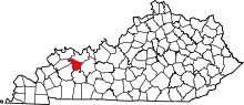 | |
| CDP | ||
| Unincorporated communities | ||