Glenmona Bridge
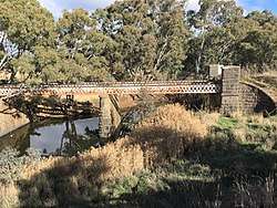
| Glenmona bridge in 2017 | |
|---|---|
 | |
| Coordinates | 37°06.203862′S 143°33.679002′E / 37.103397700°S 143.561316700°ECoordinates: 37°06.203862′S 143°33.679002′E / 37.103397700°S 143.561316700°E |
| Carries | The old Pyrenees Highway alignment |
| Crosses | Bet Bet Creek |
| Locale | Bung Bong, Victoria, Australia |
| Characteristics | |
| Design | Wrought Iron continuous lattice-girder deck-truss |
| Total length | 46.6 metres (152 ft 11 in) |
| Width | 6.1 metres (20 ft 0 in) |
| Longest span | 26 metres (85 ft 4 in)[1] |
| History | |
| Opened | 1871 |
Glenmona Bridge is a riveted wrought iron lattice-girder deck-truss road bridge on the old route between the Ararat and central goldfields over the Bet Bet Creek at Bung Bong, Victoria.
History
The bridge was built in 1871 to replace an 1857 timber bridge that was destroyed in the statewide floods of 1870. These super-floods devastated much of the state's road network, and resulted in a redesign of many river and creek crossing to raise the roads above flood levels not seen before.[2]
The continuous trusses are 46.6 metres long and the piers are quite tall at 10.1 metres high.[3] It is the third oldest of its type in Victoria. Its location is directly south of the new bridge over the Bet Bet on the Pyrenees Highway.[4]
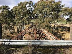
The timber deck and handrails were destroyed in a bushfire on 14 January 1985.[4]
Similar bridge
Whereas the huge lattice truss girders of the Redesdale Bridge in Redesdale, Victoria, had been imported from England in 1859, the colonial engineering works which had in the meantime developed to service reef and deep lead mining were quite capable of supplying such products for the Glenmona bridge, by 1870.[5]
Significance
The bridge is registered on the Victorian Heritage Council database[5] and with the National Trust of Australia.[3] and the Shire of Pyrenees heritage overlay.[6]
The Pyrenees Shire Council has documented the Glenmona Park homestead on Glenmona Road, Bung Bong, at the Bet Bet Creek, in the Avoca Heritage Study: 1864 - 1994 - Volume 3.[7]
See also
References
- ↑ National Trust Register citation B7055
- ↑ "The Flood". Avoca Mail. 10 September 1870. Retrieved 8 July 2017.
- 1 2 http://vhd.heritage.vic.gov.au/places/result_detail/67724 National Trust Database, Glenmona Bridge
- 1 2 "Bet Bet Creek Road Bridge (Place ID 16055)". Australian Heritage Database. Department of the Environment.
- 1 2 "Glenmona Bridge". 3 September 1999.
- ↑ Shire of Pyrenees heritage overlay HO49
- ↑ "Avoca Heritage Study: 1864 - 1994, Volume 3". Pyrenees Shire Council. February 1995. p. 149. Retrieved 20 June 2017.
External Links
- Avoca and District Historical Society
- Prior website of the Avoca and District Historical Society
- From Bung Bong to Lapstone Hill
- Colin O'Connor, Spanning Two Centuries, Historic Bridges of Australia. University of Queensland Press, 1985. p. 103