Glebe, Taghmon
| Glebe | |
|---|---|
| Townland | |
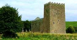 St. Munnas Church | |
 Glebe Location of Glebe within County Westmeath in the Republic of Ireland | |
| Coordinates: 53°35′55″N 7°15′33″W / 53.59861°N 7.25917°WCoordinates: 53°35′55″N 7°15′33″W / 53.59861°N 7.25917°W | |
| Country |
|
| Province | Leinster |
| County | County Westmeath |
| Irish grid reference | N490612 |
Glebe is a townland in County Westmeath, Ireland. It is located about 9.94 kilometres (6 mi) north–north–east of Mullingar.
Glebe is one of 11 townlands of the civil parish of Taghmon in the barony of Corkaree in the Province of Leinster. The townland covers 74.02 acres (0.2995 km2).
The neighbouring townlands are: Foxburrow to the north, Taghmon to the south–east, Rathcorbally and Monkstown to the south and Taghmon to the east and north.[1][2]
In the 1911 census of Ireland there were 2 houses[3] and 15 inhabitants[4] in the townland.
Glebe was the name given to an area of land within an ecclesiastical parish used to support a parish priest. As a townland name it is repeated many times across the country.[5][6]
References
- ↑ Glebe Townland, Co. Westmeath Townlands.ie Retrieved on 7 September 2015.
- ↑ Glebe Townland, Co. Westmeath IreAtlas Townland Data Base Retrieved on 7 September 2015.
- ↑ Houses in Glebe. Census of Ireland 1911. Retrieved on 7 September 2015.
- ↑ Inhabitants in Glebe. Census of Ireland 1911. Retrieved on 7 September 2015.
- ↑ Townlands of Ireland containing Glebe in the name IreAtlas Townland Data Base Retrieved on 7 September 2015.
- ↑ Townlands of Ireland named Glebe The Placenames Database of Ireland Retrieved on 7 September 2015.
External links
- Map of Glebe at openstreetmap.org
- Glebe at the IreAtlas Townland Data Base
- Glebe at Townlands.ie
- Glebe at The Placenames Database of Ireland

This article is issued from
Wikipedia.
The text is licensed under Creative Commons - Attribution - Sharealike.
Additional terms may apply for the media files.