Georgia State Route 79
| ||||
|---|---|---|---|---|
| Elberton Highway, Lincolnton Highway | ||||
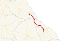 Georgia State Route 79 highlighted in red | ||||
| Route information | ||||
| Maintained by GDOT | ||||
| Length | 26.7 mi[1] (43.0 km) | |||
| Major junctions | ||||
| South end |
| |||
|
| ||||
| North end |
| |||
| Location | ||||
| Counties | Lincoln, Elbert | |||
| Highway system | ||||
| ||||

State Route 79 (SR 79) is a state highway in the east-central part of the U.S. state of Georgia. The highway runs 26.7 miles (43.0 km) from Lincolnton northwest to a point southeast of Elberton.
Route description
SR 79 begins at an intersection with US 378/SR 43 in Lincolnton. South of the intersection, the roadway continues as Goshen Street. In Chennault, the route intersects SR 44. The highway continues heading northwest to its northern terminus, an intersection with SR 72 southeast of Elberton.[1]
Major intersections
| County | Location | mi[1] | km | Destinations | Notes |
|---|---|---|---|---|---|
| Lincoln | Lincolnton | 0.0 | 0.0 | Southern terminus; roadway continues as Goshen Street | |
| Chennault | 12.6 | 20.3 | SR 44 runs southwest of SR 79; Graball Road continues northeast. | ||
| Elbert | | 26.7 | 43.0 | Northern terminus | |
| 1.000 mi = 1.609 km; 1.000 km = 0.621 mi | |||||
See also
| Wikimedia Commons has media related to Georgia State Route 79. |
.svg.png)

References
- 1 2 3 Google (October 17, 2012). "Route of SR 79" (Map). Google Maps. Google. Retrieved October 17, 2012.
External links
Route map:
This article is issued from
Wikipedia.
The text is licensed under Creative Commons - Attribution - Sharealike.
Additional terms may apply for the media files.