Gelmke
| Gelmke | |
|---|---|
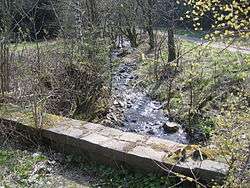 The Gelmke just upstream of the E 11 trail | |
| State | Lower Saxony, Germany |
| Reference no. | DE: 48214 |
| Physical characteristics | |
| Main source |
1.45 km ENE of the Dicker Kopf in the Harz ca. 510 m above sea level (NN) |
| River mouth |
near Oker (Goslar) into the Abzucht 51°54′36″N 10°28′34″E / 51.910°N 10.476°ECoordinates: 51°54′36″N 10°28′34″E / 51.910°N 10.476°E |
| Length | ca. 6 km |
| Basin features | |
| Progression | Abzucht→ Oker→ Aller→ Weser→ North Sea |
| Basin size | 4.6 km² [1] |
| Tributaries |
|
The Gelmke is a small stream, roughly 6 kilometres (3.7 mi) long, and right-hand tributary of the Abzucht in Lower Saxony, Germany. The stream flows through part of the town of Goslar.
Geography
The Gelmke rises in the Gelmke Valley (Gelmketal) at about 610 m above sea level (NN). Its source lies east-northeast of the hill known as the Dicker Kopf (668 m) and north of the Eichenberg (670 m).[2] It flows initially northwards through a densely wooded valley, where it is crossed by the E 11 European long-distance trail before emerging into open fields and swinging east, just above the old Goslar sewage ponds. It then heads north again to join the Abzucht near Goslar station.[2]
References
- ↑ NLWK Schriftenreihe Band 4, Gewässergütebericht 2002, Niedesächsischer Landesbetrieb für Wasserwirtschaft und Küstenschutz - Betriebsstelle Süd.
- 1 2 Bad Harzburg, Goslar, Altenau mit Brocken. 5th edition, Publicpress, Geseke. ISBN 978-3-89920-069-0.
This article is issued from
Wikipedia.
The text is licensed under Creative Commons - Attribution - Sharealike.
Additional terms may apply for the media files.