Gay Street Historic District
|
Gay Street Historic District | |
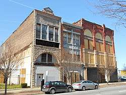 Buildings at Gay and Exeter Street, March 2012 | |
   | |
| Location | Bounded by N. Gay, Fallsway, Low and N. Exeter Sts., Baltimore, Maryland |
|---|---|
| Coordinates | 39°17′35″N 76°36′26″W / 39.29306°N 76.60722°WCoordinates: 39°17′35″N 76°36′26″W / 39.29306°N 76.60722°W |
| Area | 11 acres (4.5 ha) |
| Architect | Davis, Frank E. |
| Architectural style | Federal, Late Victorian |
| MPS | Cast Iron Architecture of Baltimore MPS |
| NRHP reference # | 03001173[1] |
| Added to NRHP | November 21, 2003 |
Gay Street Historic District is a national historic district in Baltimore, Maryland, United States. It is a notable example of a late-19th and early-20th century commercial corridor in a developing urban area. It includes a high concentration of small-scale commercial buildings or light manufacturing enterprise structures. It contains buildings displaying Victorian Eclectic, Beaux Arts, Italianate, and Romanesque elements, including two full-front, cast-iron buildings.[2]
It was added to the National Register of Historic Places in 2003.[1]
References
- 1 2 National Park Service (2010-07-09). "National Register Information System". National Register of Historic Places. National Park Service.
- ↑ Stephanie Foell and Judith Robinson (January 2003). "National Register of Historic Places Registration: Gay Street Historic District" (PDF). Maryland Historical Trust. Retrieved 2016-04-01.
External links
- Gay Street Historic District, Baltimore City, including photo dated 2003, at Maryland Historical Trust
- Boundary Map of the Gay Street Historic District, Baltimore City, at Maryland Historical Trust
| Topics |  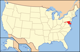 | |
|---|---|---|
| Lists by county | ||
| Lists by city | ||
| Other lists | ||
| ||
This article is issued from
Wikipedia.
The text is licensed under Creative Commons - Attribution - Sharealike.
Additional terms may apply for the media files.