Garte
| Garte | |
|---|---|
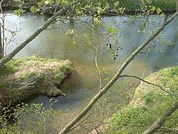 Mouth of the Garte into the Leine south of Göttingen | |
| Location |
Göttingen district, Lower Saxony, |
| Physical characteristics | |
| Main source |
east of Weißenborn at the confluence of two streams 303 m above sea level (NN) |
| River mouth |
south of Göttingen into the Leine 152 m above sea level (NN) 51°30′16″N 9°55′09″E / 51.50444°N 9.91917°ECoordinates: 51°30′16″N 9°55′09″E / 51.50444°N 9.91917°E |
| Length | 23.9 km (14.9 mi) [1] |
| Basin features | |
| Progression | Leine→ Aller→ Weser→ North Sea |
| Basin size | 89 km2 (34 sq mi) [1] |
| Tributaries |
|
The Garte is a small tributary to the Leine River in Lower Saxony, Germany.
The Garte is a 23 km long stream that rises to the east of Weißenborn at an elevation of 303 m amsl. Towns that it runs through or by include Beienrode, Kerstlingerode, Rittmarshausen (where it is joined by the Bernsroder Bach), Wöllmarshausen, Benniehausen (where the Bischhäuser Bach joins it), Klein Lengden (where the Bramke and Eichbach join it), and Diemarden. The stream joins the Leine River south of Göttingen. With a drop of 151 m, the stream averages a bed slope of 6.6‰. The watershed is 87 km². It is classified as a third-order (i.e., lowest[2]) stream according to the German system of body-of-water ranking.
The river valley is considered locally as something of a micro-cultural unit, especially solidified by the now-defunct Garte Valley Railway,[3] a 750 mm narrow-gauge railway running from Goettingen to Duderstadt.
Tributaries
from source to mouth
- (unnamed stream, from Weißenborn) (L)
- Glasehauser Bach (R)
- Moosgrund (L)
- Bernsroder Bach (R)
- Bischhäuser Bach (L)
- Bramke (R)
- Lengder Bach (R)
- Eichbach (R)