Edward G. Pitka Sr. Airport
| Edward G. Pitka Sr. Airport (former Galena Air Force Base) | |||||||||||||||
|---|---|---|---|---|---|---|---|---|---|---|---|---|---|---|---|
 | |||||||||||||||
| Summary | |||||||||||||||
| Airport type | Public | ||||||||||||||
| Owner | State of Alaska DOT&PF - Northern Region | ||||||||||||||
| Serves | Galena, Alaska | ||||||||||||||
| Elevation AMSL | 153 ft / 47 m | ||||||||||||||
| Coordinates | 64°44′10″N 156°56′15″W / 64.73611°N 156.93750°WCoordinates: 64°44′10″N 156°56′15″W / 64.73611°N 156.93750°W | ||||||||||||||
| Map | |||||||||||||||
 GAL Location of airport in Alaska | |||||||||||||||
| Runways | |||||||||||||||
| |||||||||||||||
| Statistics (2014) | |||||||||||||||
| |||||||||||||||
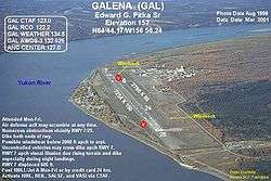
Edward G. Pitka Sr. Airport (IATA: GAL, ICAO: PAGA, FAA LID: GAL) is a state owned, public use airport located in Galena, a city in the Yukon-Koyukuk Census Area of the U.S. state of Alaska.[1]
As per Federal Aviation Administration records, the airport had 7,784 passenger boardings (enplanements) in calendar year 2008,[2] 7,447 enplanements in 2009, and 12,421 in 2010.[3] It is included in the National Plan of Integrated Airport Systems for 2011–2015, which categorized it as a non-primary commercial service airport (between 2,500 and 10,000 enplanements per year) based on enplanements in 2008,[4] however it qualifies as a primary commercial service airport based on enplanements in 2010.
History
As Galena Airport, it was used as a military transport base during World War II, facilitating the transit of Lend-Lease aircraft to the Soviet Union.
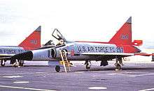
As Galena Air Force Station, it was used by the USAF during the Cold War as an interceptor base for aircraft patrolling the western areas of Alaska. It was downsized in 1993, however the military airfield is maintained by a private contractor as a weather/emergency diversion airfield since Regular Air Force fighter-interceptor alert operations ended.[5] It is now known as Galena Forward Operating Location.
Facilities and aircraft
Edward G. Pitka Sr Airport covers an area of 1,250 acres (506 ha) at an elevation of 153 feet (47 m) above mean sea level. It has two runways: 7/25 is 7,249 by 150 feet (2,209 x 46 m) with an asphalt and concrete surface; 6/24 is 2,786 by 80 feet (849 x 24 m) with a gravel ski strip surface.[1]
The airport also sports a ski-jump takeoff ramp at one end and provisions for arresting gear (see picture, ski jump at 07 end) at the other, a leftover from the Cold War years as Galena Air Force Base, as tactical aircraft required more landing and takeoff space than was available on the runway.
For the 12-month period ending May 23, 2009, the airport had 19,000 aircraft operations, an average of 52 per day: 68% general aviation, 16% scheduled commercial, 11% military, and 5% air taxi. At that time there were 13 aircraft based at this airport: 77% single-engine, 8% multi-engine, and 15% ultralight.[1]
Airlines and destinations
Passenger
| Airlines | Destinations |
|---|---|
| Ravn Alaska | Anchorage, Fairbanks, Huslia, Kaltag, Koyukuk, Nulato, Ruby[6][7] |
| Wright Air Service | Kaltag[8] |
Cargo
| Airlines | Destinations |
|---|---|
| Ravn Alaska | Fairbanks[9] |
Top destinations
| Rank | City | Passengers | Carriers |
|---|---|---|---|
| 1 | Fairbanks, AK | 7,050 | Ravn Alaska |
| 2 | Nulato, AK | 1,170 | Ravn Alaska |
| 3 | Kaltag, AK | 920 | Ravn Alaska, Wright |
| 4 | Huslia, AK | 270 | Ravn Alaska |
| 5 | Koyukuk, AK | 210 | Ravn Alaska |
| 6 | Ruby, AK | 110 | Ravn Alaska |
See also
References
- 1 2 3 4 FAA Airport Master Record for GAL (Form 5010 PDF). Federal Aviation Administration. effective May 31, 2012.
- ↑
"Enplanements for CY 2008" (PDF, 1.0 MB). CY 2008 Passenger Boarding and All-Cargo Data. Federal Aviation Administration. December 18, 2009. External link in
|work=(help) - ↑
"Enplanements for CY 2010" (PDF, 189 KB). CY 2010 Passenger Boarding and All-Cargo Data. Federal Aviation Administration. October 4, 2011. External link in
|work=(help) - ↑
"2011–2015 NPIAS Report, Appendix A" (PDF). National Plan of Integrated Airport Systems. Federal Aviation Administration. October 4, 2010. Archived from the original (PDF, 2.03 MB) on September 27, 2012. External link in
|work=(help) - ↑

- ↑ "2007 Timetable" (PDF). Frontier Flying Service. Archived from the original (PDF) on July 28, 2004. Retrieved August 29, 2007.
- ↑ http://www.flyera.com
- ↑ "Flight Schedule". Wright Air Service. Retrieved June 15, 2012.
- ↑ "Fairbanks Schedule". Arctic Circle Air. April 24, 2006.
- ↑ http://www.transtats.bts.gov/airports.asp?pn=1&Airport=GAL&Airport_Name=Galena,%20AK:%20Galena%20Airport&carrier=FACTS
External links
- Topographic map from USGS The National Map
- AIR FORCES'S ALASKA PILOTS AWAIT CALL TO INTERCEPT SOVIET CRAFT GALENA AIR FORCE STATION, Alaska
- Galena Air Force Station
- FORMER GALENA FORWARD OPERATING LOCATION
- FAA Airport Diagram for Edward G. Pitka Sr. Airport (GAL) (PDF), effective October 11, 2018
- FAA Terminal Procedures for Edward G. Pitka Sr. Airport (GAL), effective October 11, 2018
- Resources for this airport:
- FAA airport information for GAL
- AirNav airport information for PAGA
- ASN accident history for GAL
- FlightAware airport information and live flight tracker
- NOAA/NWS latest weather observations for PAGA
- SkyVector aeronautical chart for GAL
Previously: Alaskan Air Force (1941-1942) | |||||||||
| Bases |
| .svg.png) | |||||||
| Units |
| ||||||||