Gäufelden
| Gäufelden | ||
|---|---|---|
| ||
 Gäufelden Location of Gäufelden within Böblingen district 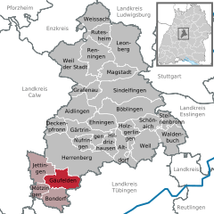  | ||
| Coordinates: 48°33′10″N 8°49′9″E / 48.55278°N 8.81917°ECoordinates: 48°33′10″N 8°49′9″E / 48.55278°N 8.81917°E | ||
| Country | Germany | |
| State | Baden-Württemberg | |
| Admin. region | Stuttgart | |
| District | Böblingen | |
| Government | ||
| • Mayor | Johannes Buchter | |
| Area | ||
| • Total | 20.07 km2 (7.75 sq mi) | |
| Elevation | 481 m (1,578 ft) | |
| Population (2017-12-31)[1] | ||
| • Total | 9,343 | |
| • Density | 470/km2 (1,200/sq mi) | |
| Time zone | CET/CEST (UTC+1/+2) | |
| Postal codes | 71126 | |
| Dialling codes | 07032 | |
| Vehicle registration | BB | |
| Website | www.gaeufelden.de | |

Gäufelden is a municipality in the administrative district of Böblingen, in the German state of Baden-Württemberg.
Geography
Gäufelden is located in the upper Gäu, 7 km from Herrenberg and 7 km from Nagold .
History
The municipality was founded July 1, 1971 by the voluntary merger of the previously independent villages of Nebringen, Öschelbronn and Tailfingen. Since then, the population has more than doubled. These three villages constitute "Ortsteile" (districts) of Gäufelden. Each district retains a Rathaus (town hall), but the administration is centralized in Öschelbronn.
Former mayors
- Herrmann Wolf (1971-2003)
References
- ↑ "Bevölkerung nach Nationalität und Geschlecht am 31. Dezember 2017". Statistisches Landesamt Baden-Württemberg (in German). 2018.
External links
- Official website

- Public Library of Gäufelden (in German)
Towns and municipalities in Böblingen (district) | ||
|---|---|---|
This article is issued from
Wikipedia.
The text is licensed under Creative Commons - Attribution - Sharealike.
Additional terms may apply for the media files.