Furneaux Group
| Native name: Tayaritja | |
|---|---|
 | |
 Furneaux Group | |
| Etymology | Tobias Furneaux |
| Geography | |
| Location | Bass Strait |
| Coordinates | 40°10′S 148°05′E / 40.167°S 148.083°ECoordinates: 40°10′S 148°05′E / 40.167°S 148.083°E |
| Total islands | approx. 100 |
| Major islands | Flinders Island, Cape Barren Island, and Clarke Island |
| Area | 2,010.3 km2 (776.2 sq mi) |
| Administration | |
| State | Tasmania |
| Local government | Flinders Council |
| Demographics | |
| Population | 795 |
The Furneaux Group (indigenous name: Tayaritja[1][2]) is a group of approximately 100 islands located at the eastern end of Bass Strait, between Victoria and Tasmania, Australia. The islands were named after British navigator Tobias Furneaux, who sighted the eastern side of these islands after leaving Adventure Bay in 1773 on his way to New Zealand to rejoin Captain James Cook.[3] Navigator Matthew Flinders was the first Westerner to explore the Furneaux Islands group in the Francis in 1798, and later that year in the Norfolk.[4]
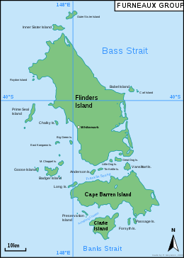
The largest islands in the group are Flinders Island, Cape Barren Island, and Clarke Island. The group contains five settlements: Killiecrankie, Emita, Lady Barron, Cape Barren Island, and Whitemark on Flinders Island, which serves as the administrative centre of the Flinders Council. there are also some small populated ranches on the remote islands.
The Furneaux Group of island became the most intensively exploited sealing ground in Bass Strait after seals were discovered there in 1798.[5] A total of 29 islands in the Furneaux Group have been found to have some tangible link with sealing in the 19th century.[6]
The Aboriginal woman Dolly Dalrymple was born in the area.[7]
King Island, at the western end of Bass Strait, is not a part of the group.
Administration
The Furneaux Group consists of approximately 100 islands. The major ones are: Anderson Island, Babel Island, Badger Island, Billy Goat Reefs, Big Green Island, Briggs Islet, Cat Island, Chalky Island, Cooties Reef, Doughboy Island, East Kangaroo Island, Fisher Island, Fisher Island Reef, Forsyth Island, Great Dog Island, Inner Sister Island, Outer Sister Island, Isabella Island, Little Anderson Island, Little Chalky Island, Little Dog Island, Little Green Island, Long Island, Low Islets, and another of the same name Low Islets, Middle Pasco Island, Mile Island, Moriarty Rocks, Mount Chappell Island, Neds Reef, Night Island, North Pasco Island, Passage Island (Tasmania), Pelican Island, Prime Seal Island, Puncheon Island, Puncheon Islets, Roydon Island, Rum Island, Samphire Island, Sentinel Island, South Pasco Island, Spences Reefs, Spike Island, Storehouse Island, Swan Island, Tin Kettle Island, Vansittart Island.
The Furneaux Group, together with the groups of islands to the north west Kent Group, Hogan Island Group, Curtis Group, Wilsons Promontory Islands (only Tasmanian part) form the Furneaux Islands Council.
Table of islands
Geology
The islands contain granite from the Devonian period, as well as unconsolidated limestone and sand from Cenozoic periods. During the ice age, a land bridge joined Tasmania to the Australian mainland through this group of islands.
See also
References
- ↑ Brown, Damien (15 June 2012). "Breathing new life into Indigenous language". ABC News. Hobart, Australia. Retrieved 10 March 2017.
- ↑ "A glossary of alternate placenames". Lands or Red and Gold. 7 July 2015. Retrieved 10 March 2017.
- ↑ Cumpston, J. S. (1973). First visitors to Bass Strait. Canberra: Roebuck Society. ISBN 0-9500858-8-X.
- ↑ Flinders, Matthew (1801). Observations on the coasts of Van Diemen’s, Land on Bass’s Strait and its islands, and on part of the coasts of New South Wales; intended to accompany the charts of the late discoveries in those countries.
- ↑ Kostoglou, Parry (1996). Sealing in Tasmania historical research project (First ed.). Hobart: Parks and Wildlife Service. pp. 90–1.
- ↑ Kostoglou, p.91.
- ↑ McFarlane, Ian (2005). Dalrymple, Dolly (c. 1808 - 1864). Australian Dictionary of Biography (Supplementary Volume ed.). Melbourne University Press. p. 94.
External links