Fumarole Butte
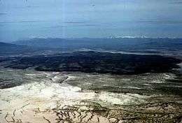
Fumarole Butte is a shield volcano in Juab County, Utah. Built during the Quaternary period, it is composed of basaltic andesite. It stands 207 meters (679 ft) in height and has a diameter of 12 kilometers (7 mi). Under the volcano lies Crater Bench, the result of an eruption of basaltic andesite. To the east of the volcano are a series of hot springs, known as Crater, Baker, or Abraham hot springs.[1]
Background
The area where Fumarole Butte is located was once dominated by Lake Bonneville, a massive body of water that took up nearly 19,750 square miles (51,152 km2). The lake was first created more than 800,000 years ago by extensive precipitation from glaciers, and has dried up and re-emerged at least 28 times since. The cycles have been matched almost exactly to periods of glaciation by drilling and stratigraphy.[2]
Description
Fumarole Butte lies north of Sevier Desert. It is located in the scoria-rich valley of a basaltic lava field,[3] on top of Tertiary-aged structures of rhyolitic lava. Made of red and gray material, its composition ranges from dark basalt to reddish scoria.[3]
Fumarole Butte formed during the Jaramillo normal event, approximately one million years ago. It is a shield volcano with a volcanic neck protruding from the center. On the edges of the volcano, lacustrine deposits can be found where the volcano was once covered by Lake Bonneville.[1]
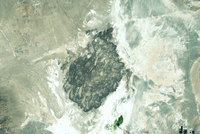
Crater Bench
Eruptions from Fumarole Butte created the basaltic Crater Bench formation, which lies beneath the neck. It is around 900,000 years of age, dated to the Pleistocene. The area is divided by faults[4] and ranges in thickness from 6 meters (20 ft) to 180 meters (591 ft). The primary component of the lava is aphyric basaltic andesite in which tiny crystalline structures are visible.[5]
References
- 1 2 Topinka, Lyn (June 11, 2003). "America's Volcanic Past: Utah". United States Geological Survey. Retrieved November 12, 2010.
- ↑ "Lake Bonneville's cycles: Climate clues". Science News. 108 (19): 296. November 8, 1975. doi:10.2307/3960485.
- 1 2 Gilbert, p. 332.
- ↑ Hecker, p. 21.
- ↑ Hintze and Davis, p. 168.
Sources
- Gilbert, Karl Grove (1890). Lake Bonneville. United States Geological Survey.
- Hecker, Suzanne (1993). Quaternary tectonics of Utah with emphasis on earthquake-hazard characterization. Utah Geological Survey.
- Hintze, Lehi F., David, Fitzhugh D., and Utah Geological Survey (2003). Geology of Millard County, Utah. Utah Geological Survey.
External links
![]()