Fultonville, New York
| Fultonville, New York | |
|---|---|
| Village | |
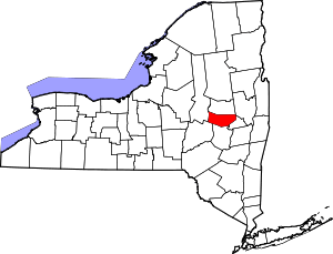
 Fultonville, New York Location within the state of New York | |
| Coordinates: 42°56′48″N 74°22′10″W / 42.94667°N 74.36944°WCoordinates: 42°56′48″N 74°22′10″W / 42.94667°N 74.36944°W | |
| Country | United States |
| State | New York |
| County | Montgomery |
| Government | |
| • Mayor | Linda Petterson-Law |
| • Treasurer | Tina Sweet |
| • Street and Water Superintendent | Ronald Kasza |
| • Clerk | Vickie Romano |
| Area | |
| • Total | 0.5 sq mi (1.3 km2) |
| • Land | 0.5 sq mi (1.2 km2) |
| • Water | 0.0 sq mi (0.1 km2) |
| Elevation | 289 ft (88 m) |
| Population (2010) | |
| • Total | 784 |
| • Estimate (2016)[1] | 782 |
| • Density | 1,600/sq mi (600/km2) |
| Time zone | UTC-5 (Eastern (EST)) |
| • Summer (DST) | UTC-4 (EDT) |
| ZIP codes | 12016, 12072 |
| Area code(s) | 518 Exchange: 853 |
| FIPS code | 36-27859 |
| GNIS feature ID | 0950807 |
Fultonville is a village in Montgomery County, New York, United States. The population was 784 at the 2010 census. The village is named after Robert Fulton, inventor of the steamboat.[2]
The Village of Fultonville is on the south bank of the Mohawk River in the Town of Glen. It is west of Amsterdam, NY. Often referred to as South Fonda.
History
The first settlement on the site was made around 1750, and was called "Van Epps Swamp" due to the swampland by the river. Homes located here were burned during the American Revolution.
The village was founded around 1824 in anticipation of the opening of the Erie Canal.
Fultonville was incorporated as a village August 9, 1848. The original board of Trustees was:
- Howland Fish - President
- Andrew J Yates
- William B Wemple
- Thomas R Horton
- Delancey D Starin
Current Trustees
- Linda S. Denton
- Stephen Helmin
- Robyn E. Rose
- Timothy Morford
Mayors of Fultonville
- John Synder [1951-1957]
- George Wadsworth [1987-1995]
- Daniel Szabo [1995-2000] [Resigned]
- Robert Headwell [2000-2016]
- George Donaldson (Interim) [2017]
- Ryan B. Weitz [2017] [Resigned after one month] [3]
- Linda Petterson-Law [Appointed May 2017, elected 2018]
Mayoral Elections:
- 1995: Daniel Szabo
- 1999: Daniel Szabo
- 2000: Robert Headwell
- 2003: Robert Headwell
- 2007: Robert Headwell
- 2011: Robert Headwell
- 2015: Robert Headwell
- 2017: Ryan Weitz
- 2018 Linda Petterson-Law
- 2016 US presidential Election Results
- Clinton(D)-144 27.61%
- Trump(R)-352 66.88%
- Johnson(L)-18 3.42%
- Stein(G)-11 2.09%
At the time of incorporation, the village's population numbered 630. In 1875, the population had increased to 1220.
Poplar Mist Boat Tours
Starting in 1991 and commencing operations in 1993, The Poplar Hotel/Restaurant offered a two and a half hour boat trip down the Mohawk River on a 102-passenger boat from mid-May through mid-October. Current efforts are underway to revive the Poplar Mist, by the current property owners BTA.
Cobblestone Hall and Free Library
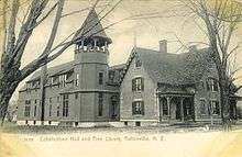
Cobblestone Hall and Free Library was built sometime before 1868 when it was the house of C.B. Freeman. Freeman was proprietor of Fultonville Steam Mills. He lived at this residence until at least 1878 when F.W. Beers published a history of Montgomery and Fulton Counties. By 1905, a large wooden addition had been made to the rear of the building and was then called "Cobblestone Free Hall and Library." The building still stands, minus the addition, and is a private residence.
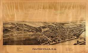
Historic photos
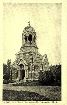 Starin Mausoleum in Fultonville Cemetery - 1907-1915
Geography
Fultonville is located at 42°56′48″N 74°22′10″W / 42.94667°N 74.36944°W (42.946764, -74.369395).[4]
According to the United States Census Bureau, the village has a total area of 0.5 square miles (1.3 km2), of which, 0.5 square miles (1.3 km2) of it is land and 0.04 square miles (0.10 km2) of it (7.69%) is water.
The village is on the south bank of the Mohawk River with the Village of Fonda on the opposite shore, linked by a bridge carrying NY-30A. The Mohawk River is part of the Erie Canal at this location.
The New York State Thruway (Interstate 90) passes through the community. New York State Route 5S (Maple Avenue), parallels the Thruway and intersects New York State Route 30A (Main Street) in Fultonville.
Demographics
| Historical population | |||
|---|---|---|---|
| Census | Pop. | %± | |
| 1870 | 1,117 | — | |
| 1880 | 881 | −21.1% | |
| 1890 | 1,122 | 27.4% | |
| 1900 | 977 | −12.9% | |
| 1910 | 812 | −16.9% | |
| 1920 | 869 | 7.0% | |
| 1930 | 831 | −4.4% | |
| 1940 | 806 | −3.0% | |
| 1950 | 840 | 4.2% | |
| 1960 | 815 | −3.0% | |
| 1970 | 812 | −0.4% | |
| 1980 | 777 | −4.3% | |
| 1990 | 748 | −3.7% | |
| 2000 | 710 | −5.1% | |
| 2010 | 784 | 10.4% | |
| Est. 2016 | 782 | [1] | −0.3% |
| U.S. Decennial Census[5] | |||
As of the census[6] of 2000, there were 710 people, 279 households, and 191 families residing in the village. The population density was 1,590.0 people per square mile (571.1/km²). There were 309 housing units at an average density of 642.8 per square mile (248.6/km²). The racial makeup of the village was 99.00% White, 1.00% Latino, 99.52% Spoke English 0.36% Spoke German 0.12% Spoke Polish
There were 279 households out of which 33.0% had children under the age of 18 living with them, 44.4% were married couples living together, 17.6% had a female householder with no husband present, and 31.2% were non-families. 25.8% of all households were made up of individuals and 11.8% had someone living alone who was 65 years of age or older. The average household size was 2.50 and the average family size was 2.96.
In the village, the population was spread out with 27.7% under the age of 18, 9.4% from 18 to 24, 26.9% from 25 to 44, 21.4% from 45 to 64, and 14.5% who were 65 years of age or older. The median age was 35 years. For every 100 females, there were 87.3 males. For every 100 females age 18 and over, there were 88.6 males.
The median income for a household in the village was $32,361, and the median income for a family was $34,167. Males had a median income of $30,500 versus $20,909 for females. The per capita income for the village was $15,283. About 3.4% of families and 6.9% of the population were below the poverty line, including 3.3% of those under age 18 and 4.5% of those age 65 or over.
Points of interest
Schools
Fultonville area residents attend the Fonda-Fultonville Central School District, located in Fonda, New York.
Houses of worship
 Reformed Church - 1907-1915
 Methodist Church - 1907-1915
 Calvary Baptist Church - 1907-1915
- Fultonville Reformed Church
- Fonda-Fultonville United Methodist Church [No longer in use due to fire 3/14/17
- Calvary Baptist Church [No Longer in Use]
Cemeteries
- Maple Avenue Cemetery - Est. 1874
- Old Fultonville Cemetery
References
- 1 2 "Population and Housing Unit Estimates". Retrieved June 9, 2017.
- ↑ Zurlo, Sam (15 April 1996). "Area place names reflect local history and personalities". The Daily Gazette. pp. B5. Retrieved 23 April 2015.
- ↑ Frisch, Morgan (3 May 2017). "Weitz, Dimezzas resign from positions in Fultonville". The Recorder. Retrieved 9 July 2018.
- ↑ "US Gazetteer files: 2010, 2000, and 1990". United States Census Bureau. 2011-02-12. Retrieved 2011-04-23.
- ↑ "Census of Population and Housing". Census.gov. Archived from the original on May 12, 2015. Retrieved June 4, 2015.
- ↑ "American FactFinder". United States Census Bureau. Archived from the original on 2013-09-11. Retrieved 2008-01-31.