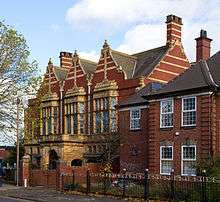
Friends' Institute buildings
The Friends Institute Buildings are a former Religious Society of Friends (Quaker) meeting house, community facilities, and associated structures, at 200, Moseley Road, Balsall Heath, Birmingham, England. The various parts are now used as a church, school and the Moseley Road Community Centre. In September 2014, the buildings were granted Grade II* designation.[1][2][3]
History
The buildings were completed in 1897,[2] to designs by local architect Ewan Harper, possibly with the involvement of his younger brother James, and paid for by local philanthropists (and Quakers) the Cadbury family, chiefly Richard Cadbury.[1]
The Yearly Meeting for Quakers, was held in the building (instead of its usual London venue) in 1908 and 1954.[1]
The hall's original organ was replaced by larger instrument (now missing). A war memorial was installed on the staircase.[1]
The Dolobran Athletics Club had use of the basement, as a gymnasium. The first international athletics match between England, Ireland and Scotland was held there in March 1900.[1][3]
Design
The red brick building, with terracotta decoration, is little altered, inside and out. The original 37 classrooms remain, though some dividing walls have been removed.[1] An assembly hall, with the capacity for 2,000 people, is at the rear.[1] The entrance leads to a central corridor, flanked by a reading room and a coffee room, with a lecture room above.[1]
Current use
The assembly room is now owned and used by the New Testament Church.[1] The remainder is owned by Birmingham City Council, part used as a school and part for community functions.[1]
References
- 1 2 3 4 5 6 7 8 9 10 English heritage survey report
- 1 2 Historic England. "Details from listed building database (1418995)". National Heritage List for England. Retrieved 6 October 2014.
- 1 2 Barnfield, Stacey (6 October 2014). "Friends' Institute Quaker building on Moseley Road handed Grade II* listed status - Birmingham Post". Birmingham Post. Retrieved 6 October 2014.
| Wikimedia Commons has media related to Friends Institute, Birmingham. |
External links
- Historic England. "Details from listed building database (1418995)". National Heritage List for England.
Coordinates: 52°27′56″N 1°52′57″W / 52.465443°N 1.882387°W