Friedrichsberg (Lower Bavaria)
| Friedrichsberg | |
|---|---|
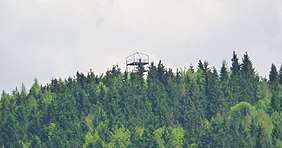 The viewing tower at the top | |
| Highest point | |
| Elevation | 930 m above sea level (NHN) (3,050 ft) [1] |
| Listing | Viewing tower |
| Coordinates | 48°39′17″N 13°47′48″E / 48.6546°N 13.7966°ECoordinates: 48°39′17″N 13°47′48″E / 48.6546°N 13.7966°E |
| Geography | |
| Parent range | Bavarian Forest |
| Geology | |
| Type of rock | gneiss |

The Lower Bavarian Friedrichsberg is a mountain, 930 m above sea level (NHN), in the southern Bavarian Forest in Germany between the villages of Breitenberg and Wegscheid in the county of Passau not far from the border with Upper Austria.
For several years a viewing tower has stood at the top, which offers an all-round view. On clear days in föhn conditions, the chain of the Alps may be seen from the Totes Gebirge to the Kaiser Mountains. The Friedrichsberg may be climbed in a short time using one of several footpaths from the surrounding villages and hamlets.

References
This article is issued from
Wikipedia.
The text is licensed under Creative Commons - Attribution - Sharealike.
Additional terms may apply for the media files.