Friedrich-Wilhelm-Lübke-Koog
| Friedrich-Wilhelm-Lübke-Koog | |
|---|---|
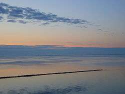 The coastline of Friedrich-Wilhelm-Lübke-Koog as seen from the Hindenburgdamm causeway | |
 Friedrich-Wilhelm-Lübke-Koog Location of Friedrich-Wilhelm-Lübke-Koog within Nordfriesland district 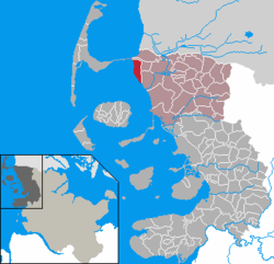 | |
| Coordinates: 54°52′N 8°38′E / 54.867°N 8.633°ECoordinates: 54°52′N 8°38′E / 54.867°N 8.633°E | |
| Country | Germany |
| State | Schleswig-Holstein |
| District | Nordfriesland |
| Municipal assoc. | Südtondern |
| Government | |
| • Mayor | Carl-August thor Straten |
| Area | |
| • Total | 13.49 km2 (5.21 sq mi) |
| Elevation | 1 m (3 ft) |
| Population (2016-12-31)[1] | |
| • Total | 166 |
| • Density | 12/km2 (32/sq mi) |
| Time zone | CET/CEST (UTC+1/+2) |
| Postal codes | 25924 |
| Dialling codes | 04668 |
| Vehicle registration | NF |
| Website | www.amt-suedtondern.de |
Friedrich-Wilhelm-Lübke-Koog is a municipality in the district of Nordfriesland, in Schleswig-Holstein, Germany.
The municipality is located in and named after the polder (German: Koog), which was finished in 1954 and named in honour of Schleswig-Holstein's Minister-President Friedrich-Wilhelm Lübke (in German), who had died the same year.
References
This article is issued from
Wikipedia.
The text is licensed under Creative Commons - Attribution - Sharealike.
Additional terms may apply for the media files.