Freetown, Indiana
| Freetown, Indiana | |
|---|---|
| Census-designated place | |
 | |
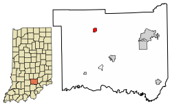 Location of Freetown in Jackson County, Indiana | |
 Freetown Location of Freetown in Jackson County, Indiana  Freetown Freetown (the US) | |
| Coordinates: 38°58′23″N 86°07′46″W / 38.97306°N 86.12944°WCoordinates: 38°58′23″N 86°07′46″W / 38.97306°N 86.12944°W | |
| Country | United States |
| State | Indiana |
| County | Jackson |
| Township | Pershing |
| Area | |
| • Total | 0.73 sq mi (1.88 km2) |
| • Land | 0.73 sq mi (1.88 km2) |
| • Water | 0.004 sq mi (0.01 km2) |
| Elevation | 650 ft (200 m) |
| Population (2010) | |
| • Total | 385 |
| • Density | 532/sq mi (205.3/km2) |
| ZIP code | 47235 |
| FIPS code | 18-25864[1] |
| GNIS feature ID | 450936[2] |
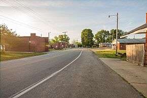
Freetown is an unincorporated community and census-designated place in Pershing Township, Jackson County, Indiana, United States. As of the 2010 census the population was 385.[1]
History
Freetown was platted in 1850.[3] A post office was established at Freetown in 1850.[4]
The Frank Wheeler Hotel was listed on the National Register of Historic Places in 1991.[5]
Geography
Freetown is located in northwestern Jackson County at 38°58′23″N 86°07′46″W / 38.97306°N 86.12944°W. It is bordered to the west by Hoosier National Forest. Indiana State Road 135 passes through the west side of the community, leading north 18 miles (29 km) to Gnaw Bone and south 11 miles (18 km) to Brownstown, the Jackson county seat. State Road 58 passes through the west and north sides of the community, leading northeast 23 miles (37 km) to Columbus and southwest 27 miles (43 km) to Bedford.
According to the U.S. Census Bureau, the Freetown CDP has a total area of 0.73 square miles (1.88 km2), of which 1.9 acres (7,820 m2), or 0.42%, are water.[1]
Demographics
| Historical population | |||
|---|---|---|---|
| Census | Pop. | %± | |
| U.S. Decennial Census[6] | |||
References
- 1 2 3 "Geographic Identifiers: 2010 Census Summary File 1 (G001): Freetown CDP, Indiana". American Factfinder. U.S. Census Bureau. Retrieved May 15, 2018.
- ↑ "Freetown, Indiana". Geographic Names Information System. United States Geological Survey. Retrieved 2009-10-17.
- ↑ History of Jackson County, Indiana: From the Earliest Time to the Present, with Biographical Sketches, Notes, Etc., Together with an Extended History of the Northwest, the Indiana Territory and the State of Indiana. Unigraphic. 1886. p. 443.
- ↑ "Jackson County". Jim Forte Postal History. Archived from the original on 19 October 2014. Retrieved 19 October 2014.
- ↑ National Park Service (2010-07-09). "National Register Information System". National Register of Historic Places. National Park Service.
- ↑ "Census of Population and Housing". Census.gov. Retrieved June 4, 2016.
Municipalities and communities of Jackson County, Indiana, United States | ||
|---|---|---|
| City | ||
| Towns | ||
| Townships | ||
| CDPs | ||
| Other unincorporated communities | ||
| Authority control |
|---|