Fratton
| Fratton | |
|---|---|
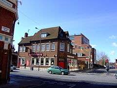 The Froddington Arms, Fratton | |
 Fratton Fratton shown within Hampshire | |
| Population | 15,314 (2011.Ward)[1] |
| OS grid reference | SU655005 |
| Unitary authority | |
| Ceremonial county | |
| Region | |
| Country | England |
| Sovereign state | United Kingdom |
| Post town | PORTSMOUTH |
| Postcode district | PO1 |
| Dialling code | 023 |
| Police | Hampshire |
| Fire | Hampshire |
| Ambulance | South Central |
| EU Parliament | South East England |
| UK Parliament | |
Fratton is a residential and formerly industrial area of Portsmouth, in Hampshire, England.[2][3] It consists of mostly Victorian terraced houses, and is typical of the residential areas in the city.
There is also a modest shopping centre on Fratton Road, called The Bridge Centre, which is dominated by a large Asda supermarket and Various Vacant Units, and in atmosphere reflects the working class roots of the neighbourhood, with local, low-budget shops and cafes.
Fratton is also one of the four railway stations on Portsea Island. Due to its location as the last stop before the main Portsmouth railway station (Portsmouth & Southsea), Fratton has been adopted in naval slang as a euphemism for the withdrawal method of contraception, "getting off at Fratton".[4]
History
The name Fratton was once Froddington, a Saxon name which originally meant "Frodda's Farm" or "Frodda's village". A pub on Fratton Road is still named "The Froddington Arms".[5]
Goldsmith's Farm and Fratton Common were part of the original small rural village originally called Froddington, the only visible evidence of this being the presence of a public house, "The Froddington Arms" on the western side of Fratton Road. Froddington was one of the three small settlements on Portsea Island mentioned in the Domesday Book. Due to developments during the Industrial age, more of the surrounding land was absorbed by Portsmouth in the 1870s and 1880s, principally by new housing developments.
Trivia
- Despite its well known name, Portsmouth F.C.'s Fratton Park stadium is not built in the Fratton district of Portsmouth, it was actually built between 1898-1899 on farmland around the (then) village of Milton on the eastern side of Portsea Island. The Fratton Park stadium today still resides within the neighbouring Milton district of Portsmouth. This can be proven from the current Portsmouth FC postal code, "PO4 8RA" which has a "PO4" prefix Milton district postal code, not a Fratton (and Portsmouth city centre) "PO1" prefixed code. The streets and houses immediately around Fratton Park are officially designated as being within the "Milton Ward" district for local and national governmental elections. The boundary line between Fratton and Milton is marked along the Portsmouth Direct Line railway line. Fratton Park is located south of the railway line and is therefore within the Milton district.
- Fratton Park's name was deliberately (and misleadingly) chosen in 1899 to persuade users of Fratton railway and tram station that Portsmouth FC's football ground was nearer to convenient transport links than it actually was. The distance from Fratton railway station to Fratton Park is approximately one mile away along Goldsmith Avenue and takes ten minutes walk to complete.
References
- ↑ "Portsmouth Ward population 2011". Retrieved 18 October 2015.
- ↑ Ordnance Survey: Landranger map sheet 196 The Solent & Isle of Wight (Southampton & Portsmouth) (Map). Ordnance Survey. 2015. ISBN 9780319231425.
- ↑ "Ordnance Survey: 1:50,000 Scale Gazetteer" (csv (download)). www.ordnancesurvey.co.uk. Ordnance Survey. 1 January 2016. Retrieved 18 February 2016.
- ↑ http://qi.com/infocloud/the-navy
- ↑ http://www.localhistories.org/fratton.html