Frankenfels
| Frankenfels | ||
|---|---|---|
| ||
 Frankenfels Location within Austria | ||
| Coordinates: 47°58′N 15°19′E / 47.967°N 15.317°ECoordinates: 47°58′N 15°19′E / 47.967°N 15.317°E | ||
| Country | Austria | |
| State | Lower Austria | |
| District | Sankt Pölten-Land | |
| Government | ||
| • Mayor | Franz Größbacher (SPÖ) | |
| Area | ||
| • Total | 56.16 km2 (21.68 sq mi) | |
| Elevation | 464 m (1,522 ft) | |
| Population (1 January 2016)[1] | ||
| • Total | 2,021 | |
| • Density | 36/km2 (93/sq mi) | |
| Time zone | UTC+1 (CET) | |
| • Summer (DST) | UTC+2 (CEST) | |
| Postal code | 3213 | |
| Area code | 02725 | |
| Website | http://www.frankenfels.at | |

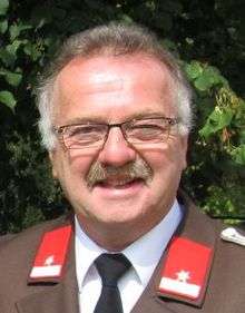
Mayor Franz Größbacher (2012)
Frankenfels is a market town with 1989 inhabitants (2017) in St. Pölten-Land which is a district of the state of Lower Austria, Austria.
Population
| Historical population | ||
|---|---|---|
| Year | Pop. | ±% |
| 1971 | 1,989 | — |
| 1981 | 2,026 | +1.9% |
| 1991 | 2,118 | +4.5% |
| 2001 | 2,187 | +3.3% |
| 2015 | 2,025 | −7.4% |
| 2017 | 1,989 | −1.8% |
Sights
- The cave of Nixhöhle de
- The Falkensteinmauer
- The Taubenbachklamm
- The Weißenburg
References
This article is issued from
Wikipedia.
The text is licensed under Creative Commons - Attribution - Sharealike.
Additional terms may apply for the media files.