Eichgraben
| Eichgraben | ||
|---|---|---|
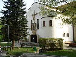 Main portal of the Roman Catholic Heart of Jesus Peace Church in Eichgraben named "Duomo of Vienna Woods" with crucifixion ensemble from sandstone of Adolf Treberer-Treberspurg | ||
| ||
 Eichgraben Location within Austria | ||
| Coordinates: 48°10′22″N 15°59′0″E / 48.17278°N 15.98333°ECoordinates: 48°10′22″N 15°59′0″E / 48.17278°N 15.98333°E | ||
| Country | Austria | |
| State | Lower Austria | |
| District | Sankt Pölten-Land | |
| Government | ||
| • Mayor | Martin Michalitsch | |
| Area | ||
| • Total | 8.88 km2 (3.43 sq mi) | |
| Elevation | 286 m (938 ft) | |
| Population (1 January 2016)[1] | ||
| • Total | 4,555 | |
| • Density | 510/km2 (1,300/sq mi) | |
| Time zone | UTC+1 (CET) | |
| • Summer (DST) | UTC+2 (CEST) | |
| Postal code | 3032 | |
| Area code | 02773 | |
| Website | http://www.eichgraben.at | |

Eichgraben is a town in the district of Sankt Pölten-Land in the Austrian state of Lower Austria.
Population
| Historical population | ||
|---|---|---|
| Year | Pop. | ±% |
| 1794 | 346 | — |
| 1830 | 354 | +2.3% |
| 1869 | 578 | +63.3% |
| 1880 | 583 | +0.9% |
| 1890 | 636 | +9.1% |
| 1900 | 874 | +37.4% |
| 1910 | 1,303 | +49.1% |
| 1923 | 1,380 | +5.9% |
| 1934 | 1,737 | +25.9% |
| 1939 | 1,822 | +4.9% |
| 1951 | 2,118 | +16.2% |
| 1961 | 2,050 | −3.2% |
| 1971 | 2,321 | +13.2% |
| 1981 | 2,642 | +13.8% |
| 1991 | 3,344 | +26.6% |
| 2001 | 3,748 | +12.1% |
| 2011 | 4,309 | +15.0% |
References
| Authority control |
|---|
This article is issued from
Wikipedia.
The text is licensed under Creative Commons - Attribution - Sharealike.
Additional terms may apply for the media files.