Fort Valley (Virginia)
| Fort Valley | |
|---|---|
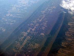 Air photo of Fort Valley, facing south, with the North (right) and South (left) Forks of the Shenandoah River visible. February 2009. | |
| Location | Shenandoah County, Virginia |
| Long-axis direction | North to south |
| Long-axis length | 23 miles (37 km) |
| Geography | |
| Bounded by | Massanutten Mountain (all sides) |
| Coordinates | 38°48′00″N 78°27′40″W / 38.800°N 78.461°WCoordinates: 38°48′00″N 78°27′40″W / 38.800°N 78.461°W |
| Traversed by | S.R. 678 |
Fort Valley is a mountain valley in Shenandoah County, Virginia.[1] The so-called "valley within a valley" lies between the two arms of the northern Massanutten Mountain range in the Shenandoah Valley. The valley is closed at its southern end, and is constricted and nearly closed to the north, where Passage Creek flows through a narrow gap. The valley opens out toward the center, becoming about three miles (4.8 km) wide at its widest. In all, Fort Valley is 23 miles (37 km) long.
Fort Valley is mostly rural, consisting of private farmland, surrounded by the George Washington National Forest (GWNF), which covers the slopes on both the east and west mountains. The Elizabeth Furnace and Camp Roosevelt Recreation Area of the GWNF are located within Fort Valley.
Roads exit the valley at its northern end (S.R. 678) between Strasburg and Front Royal, at Edinburg Gap (S.R. 675) towards Edinburg, Moreland Gap (S.R. 730) towards New Market, and Edith Gap (S.R. 675) towards Luray. There is also a dirt road that leads to Woodstock (S.R 758) over Powell Mountain.
History
According to tradition, Daniel Morgan built the first road into Fort Valley from the north, at the order of George Washington, with a view to holing up in this naturally fortified valley as a possible last stand against the British during the American Revolution. The Continental Army's victory at Yorktown altered Washington's plans.
The Daniel Munch House was listed on the National Register of Historic Places in 2002.[2]
References
- ↑ "Fort Valley". Geographic Names Information System. United States Geological Survey. Retrieved December 12, 2016.
- ↑ National Park Service (2010-07-09). "National Register Information System". National Register of Historic Places. National Park Service.