Forollhogna
| Forollhogna | |
|---|---|
| Forolhogna | |
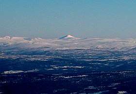 Forollhogna (image center) as seen from Ilfjellet (west) | |
| Highest point | |
| Elevation | 1,332 m (4,370 ft) |
| Prominence | 700 m (2,300 ft) [1] |
| Isolation | 35.9 kilometres (22.3 mi) |
| Coordinates | 62°40′44″N 10°47′33″E / 62.6789°N 10.7924°ECoordinates: 62°40′44″N 10°47′33″E / 62.6789°N 10.7924°E [2] |
| Geography | |
 Forollhogna Location of the mountain 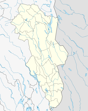 Forollhogna Forollhogna (Hedmark)  Forollhogna Forollhogna (Norway) | |
| Location | Trøndelag and Hedmark, Norway |
| Topo map | 1620 II Dalsbygda |
Forollhogna (or Forolhogna) is a mountain located on the border between three municipalities in Norway: Midtre Gauldal and Holtålen (in Trøndelag county) and Os (in Hedmark county). The 1,332-metre (4,370 ft) tall mountain Forollhogna is the highest mountain inside Forollhogna National Park.[3]
The mountain is about 27 kilometres (17 mi) southeast of the village of Enodden in Midtre Gauldal and about 30 kilometres (19 mi) northwest of town of Røros.
References
- ↑ "Forolhogna 1332 moh - fakta" (in Norwegian). Toppomania. Retrieved 2011-02-13.
- ↑ "Forollhogna, Midtre Gauldal (Trøndelag)" (in Norwegian). yr.no. Retrieved 2018-01-18.
- ↑ Mæhlum, Lars, ed. (2017-10-27). "Forollhogna". Store norske leksikon (in Norwegian). Kunnskapsforlaget. Retrieved 2018-01-18.
This article is issued from
Wikipedia.
The text is licensed under Creative Commons - Attribution - Sharealike.
Additional terms may apply for the media files.