Formigine
| Formigine | |
|---|---|
| Comune | |
| Comune di Formigine | |
 | |
 Formigine Location of Formigine in Italy | |
| Coordinates: 44°36′26″N 10°56′0″E / 44.60722°N 10.93333°ECoordinates: 44°36′26″N 10°56′0″E / 44.60722°N 10.93333°E | |
| Country | Italy |
| Region | Emilia-Romagna |
| Province | Modena (MO) |
| Frazioni | Casinalbo, Colombaro, Corlo, Magreta |
| Government | |
| • Mayor | Maria Costi |
| Area | |
| • Total | 46.74 km2 (18.05 sq mi) |
| Elevation | 82 m (269 ft) |
| Population (31 March 2017) | |
| • Total | 34,328 |
| • Density | 730/km2 (1,900/sq mi) |
| Demonym(s) | Formiginesi |
| Time zone | UTC+1 (CET) |
| • Summer (DST) | UTC+2 (CEST) |
| Postal code | 41043 |
| Dialing code | 059 |
| Patron saint | St. Bartholomew |
| Saint day | 24 August |
| Website | Official website |
Formigine (Modenese: Furméżen) is a town and comune in the province of Modena, Emilia-Romagna, Italy. As of 2007 Formigine had an estimated population of 31,643.[1]
History
Formigine originates from the foundation of its castle in 1201 by the Comune of Modena, as a defence against Reggio Emilia, during a war started over the control of the waters to convey to the many canals departing from the river Secchia. In 1395 Niccolò III d'Este gave it in fiefdom to Marco Pio, lord of Carpi.
Main sights
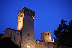
- Medieval castle (thirteenth century)in the Town centre.
- Villa Gandini, in the 'Park of the Resistance' Via San Antonio (now housing the public library)
- Hermit Enrico's house (now museum)
- San Bartolomeo Church in the Town centre opposite the Castle.
People
- Andrea da Formigine (circa 1485 - 1559), Italian architect of the Renaissance period, active mainly in Bologna.
- Cristian Zaccardo, World Cup-winning footballer
- Riccardo Riccò, cyclist
Twin towns
Sources
- ↑ "The World Gazetteer". Archived from the original on 2007-09-30. Retrieved 2007-02-23.

| Authority control |
|---|
This article is issued from
Wikipedia.
The text is licensed under Creative Commons - Attribution - Sharealike.
Additional terms may apply for the media files.