Forbordsfjellet
| Forbordsfjellet | |
|---|---|
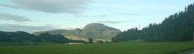 Forbordsfjellet seen from Rykkja | |
| Highest point | |
| Elevation | 590 m (1,940 ft) |
| Prominence | 360 m (1,180 ft) |
| Coordinates | 63°31′32″N 10°53′22″E / 63.52556°N 10.88944°ECoordinates: 63°31′32″N 10°53′22″E / 63.52556°N 10.88944°E [1] |
| Geography | |
 Forbordsfjellet Location of the mountain  Forbordsfjellet Forbordsfjellet (Norway) | |
| Location | Trøndelag, Norway |
| Topo map | 1621 I Stjørdal and 1622 II Frosta |
Forbordsfjellet is a mountain in the municipality of Stjørdal in Trøndelag county, Norway. The 590-metre (1,940 ft) tall mountain lies directly to the north of Trondheim Airport, Værnes and the town of Stjørdalshalsen and about 4 kilometres (2.5 mi) northeast of the village of Skatval. There is a toll road to the summit from European route E6 near Skatval Church.[2]
References
- ↑ "Forbordsfjellet, Stjørdal (Trøndelag)" (in Norwegian). yr.no. Retrieved 2017-03-27.
- ↑ "Forbordsfjellet 590 moh - fakta" (in Norwegian). Toppomania. Archived from the original on 2011-09-29. Retrieved 2011-05-17.
This article is issued from
Wikipedia.
The text is licensed under Creative Commons - Attribution - Sharealike.
Additional terms may apply for the media files.