Fond du Lac River (Wisconsin)
| Fond du Lac River | |
|---|---|
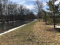 The Fond du Lac River as it passes through the Town of Fond du Lac | |
 Fond du Lac River  Fond du Lac River | |
| Location | Fond du Lac County, Wisconsin |
| Coordinates | 43°48′02″N 88°27′09″W / 43.8005443°N 88.4526073°WCoordinates: 43°48′02″N 88°27′09″W / 43.8005443°N 88.4526073°W |
| Primary outflows | Lake Winnebago |
| Surface elevation | 751 feet (229 m) |
| Settlements | Fond du Lac |
The Fond du Lac River is a river that flows through the city of Fond du Lac, Wisconsin into Lake Winnebago.[1] The river starts near Rosendale, Lamartine and Eldorado, then flows around 10 miles east.[2] The east and west branches come together in downtown Fond du Lac less than a mile before flowing into Lake Winnebago.[3]
The Supple Marsh, and Lakeside Park border the river as it flows into Lake Winnebago.
References
- ↑ "Report for Fond du Lac River". USGNIS. Retrieved April 13, 2018.
- ↑ [file:///home/chronos/u-6e89d1c72eefda2266631940d3a73e5798f5ab70/Downloads/UF03_WTPLAN%20(2).pdf "Fond du Lac River Watershed"] Check
|url=value (help) (PDF). Wisconsin DNR. Retrieved April 13, 2018. - ↑ "Fond du Lac River Watershed". Wisconsin DNR. Retrieved April 13, 2018.
This article is issued from
Wikipedia.
The text is licensed under Creative Commons - Attribution - Sharealike.
Additional terms may apply for the media files.