Fnjóskadalur
| Fnjóskadalur | |
|---|---|
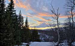 View from Vaglaskógur forest | |
| Coordinates: 65°44′N 17°54′W / 65.733°N 17.900°WCoordinates: 65°44′N 17°54′W / 65.733°N 17.900°W | |
| Country | Iceland |
| County | Suður-Þingeyjarsýsla |
| Municipality | Þingeyjarsveit |
Fnjóskadalur is an agricultural valley in Northeast Iceland, approx. 10 km northeast of Akureyri. Fnjóská, a popular salmon angling river and the longest spring fed river in Iceland, runs through the valley. The river originates on Sprengisandur in the Icelandic highland plateau.[1]
Overview
Vaglaskógur, the second largest forest in Iceland, is located around the center of the valley. Other woods in Fnjóskadalur are Lundsskógur, Þórðarstaðaskógur south of Vaglaskógur, and Skuggabjargarskógur in Dalsmynni, the extreme northern portion of the valley.
Þverá is the northernmost farm in Fnjóskadalur, located where the valley branches into Dalsmynni to the northwest, leading to sea in Eyjafjörður; and the much longer Flateyjardalur to the northeast, leading to sea in Skjálfandi bay.
Etymology
The name Fnjóskadalur is formed from the Icelandic words fnjóskur (a dry piece of wood) and dalur (valley).[2]
References
- ↑ "Visitnortheasticeland.is - official travel web site in English". Retrieved 9 March 2011.
- ↑ "Norðausturland.is - official travel web site in Icelandic". Retrieved 9 March 2011.