Florencia de Benito Juárez
| Benito Juárez Florencia de Benito Juárez | |
|---|---|
| Nickname(s): Florencia | |
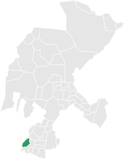 Location within the state of Zacatecas | |
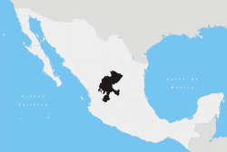
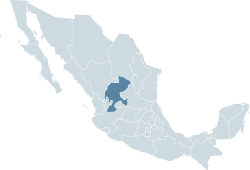 Zacatecas' location within Mexico | |
| Country |
|
| State | Zacatecas |
| Municipality | Benito Juárez [1] |
| Elevation | 2,200 m (7,217.84777 ft) |
| Time zone | UTC-6 (Central (US Central)) |
| • Summer (DST) | UTC-5 (Central) |
| Postal code | 99780,99781[2] |
| Website | Official website |
Benito Juárez Municipality is a Mexican municipality located in the southern extreme of the state of Zacatecas on the edge of the Canyon of Tlaltenango.
Overview
To the north, the municipality is bordered by the municipality of Tepechitlán, and Chimaltitan, Jalisco. To the south, the municipality is bordered by the municipality of Teúl de González Ortega and Tequila, Jalisco. To the east it is bordered by Teúl de González Ortega, and Santa María de la Paz. To the west, it is bordered by the municipality of San_Martin_de_Bolanos,Jalisco.
The municipality covers an area of 329 km². Its villages include Los Campos, San Lucas, Potrerillos, and Tonilco.
In 2010, the municipality had a total of 4,854 inhabitants, of which 2,406 lived in the municipal seat.
References
External links and Sources
- Municipio de Benito juarez
- Mexico's Instituto Nacional de Estadística Geografía e Informática
- Mexican postal service
- state of Zacatecas(official) municipal(county) map
Coordinates: 23°51′50″N 103°23′19″W / 23.8638888989°N 103.388611121°W
Zacatecas (capital) | ||
| Municipalities and (municipal seats) |
|  |