Flin Flon Airport
| Flin Flon Airport | |||||||||||
|---|---|---|---|---|---|---|---|---|---|---|---|
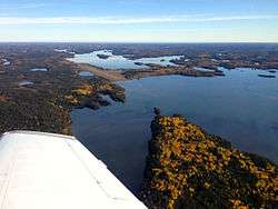 Flin Flon airport as seen from the south | |||||||||||
| Summary | |||||||||||
| Airport type | Public | ||||||||||
| Operator | City of Flin Flon | ||||||||||
| Location | Rural Municipality of Kelsey, near Flin Flon, Manitoba | ||||||||||
| Time zone | CST (UTC−06:00) | ||||||||||
| • Summer (DST) | CDT (UTC−05:00) | ||||||||||
| Elevation AMSL | 998 ft / 304 m | ||||||||||
| Coordinates | 54°40′41″N 101°40′55″W / 54.67806°N 101.68194°WCoordinates: 54°40′41″N 101°40′55″W / 54.67806°N 101.68194°W | ||||||||||
| Map | |||||||||||
 CYFO Location in Manitoba | |||||||||||
| Runways | |||||||||||
| |||||||||||
| Statistics (2010) | |||||||||||
| |||||||||||
Flin Flon Airport, (IATA: YFO, ICAO: CYFO), is located 8 nautical miles (15 km; 9.2 mi) southeast of Flin Flon, Manitoba, Canada, in the community of Bakers Narrows, on the shores of Lake Athapapuskow.
Airlines and destinations
| Airlines | Destinations |
|---|---|
| Calm Air | The Pas, Thompson, Winnipeg |
| Missinippi Air | The Pas, Saskatoon |
See also
References
- ↑ Canada Flight Supplement. Effective 0901Z 19 July 2018 to 0901Z 13 September 2018.
- ↑ Total aircraft movements by class of operation
External links
- Page about this airport on COPA's Places to Fly airport directory
- Past three hours METARs, SPECI and current TAFs for Flin Flon Airport from Nav Canada as available.
| By name | |
|---|---|
| By location indicator | |
| By province/territory | |
| By area | |
| National Airports System | |
| Related | |
| |
This article is issued from
Wikipedia.
The text is licensed under Creative Commons - Attribution - Sharealike.
Additional terms may apply for the media files.