Fixed-point ocean observatory
A fixed-point ocean observatory is an autonomous system of automatic sensors and samplers that continuously gathers data from deep sea, water column and lower atmosphere, and transmits the data to shore in real or near real-time.
Infrastructure
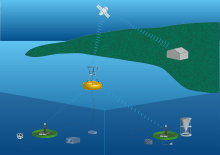
Fixed-point ocean observatories are typically composed of a cable anchored to the sea floor to which several automatic sensors and samplers are attached. The cable ends with a buoy at the ocean surface that may have some more sensors attached.[1] Most observatories have communicating buoys that transmit data to shore, and which allow changes to the acquisition method of the sensors, as required.
These unmanned platforms can be linked via a cable to the shore transmitting data via an internet connection, or they can transmit data to relay buoys which are able to provide a satellite link to the shore.
Instrumentation
A typical multi-disciplinary observatory is equipped with sensors and instruments to measure physical and biogeochemical variables along the water column. Additionally the surface buoy can hold several sensors measuring atmospheric parameters at sea level.[2] Main measured variables:
| Sea surface |
Sea-surface temperature (SST)
Sea-surface salinity (SSS)
|
| Sub-surface |
Temperature
Salinity
|
| Atmosphere (Surface) |
Air Temperature
|
In order to do so, typically the ocean observatories are equipped with instruments like:
- ADCP – Acoustic Doppler current profiler, to measure currents;
- CTD (conductivity, temperature and depth) sensors, to measure conductivity and thermal variations at a known depth;
- Hydrophone – to record sounds;
- Sediment Trap – to quantify the quantity of sinking material;
- Deep sea camera – to capture footage on location;
- Seismometer – to record the earth motion;
- CO2 analyser – to measure CO2;
- Dissolved Oxygen sensor – to measure dissolved oxygen;
- Fluorometers – to measure Chlorophyll;
- Turbidity sensor – to measure turbidity.
Purpose
Ocean observatories can collect data for different purposes from scientific research to environmental monitoring for marine operations or governance for the benefit of economy and society as a whole. Ocean observatories provide real-time, or near real time data allowing to detect changes as they happen, such as geo-hazards for example. Furthermore continuous time series data allow to investigate interannual-to-decadal changes and to capture episodic events, changes in ocean circulation, water properties, water mass formation and ecosystems, to quantify air-sea fluxes, and to analyse the role of the oceans for the climate.[3]
The data collected by the several ocean observatories around the globe on the sub-sea-floor, seafloor, and water column, allows to improve our knowledge[4] of the ocean including:
- Ocean physics and climate change
- Biodiversity and ecosystem assessment
- Carbon cycle and ocean acidification
- Geophysics and geodynamics
Moreover networks of ocean observatories can also be used to input data into global ocean models and to calibrate them thus allowing for the investigation of future changes in ocean circulation and ecosystems.
References
- ↑ FixO3 Project Factsheet http://www.fixo3.eu/
- ↑ Ruhl et al, Societal need for improved understanding of climate change, anthropogenic impacts, and geo-hazard warning drive development of ocean observatories in European Seas, Progress in Oceanography, Volume 91, Issue 1, October 2011, Pages 1–33 (doi:10.1016/j.pocean.2011.05.001) , additional text.
- ↑ Ocean Reference Stations, Meghan F. Cronin, Robert A. Weller, Richard S. Lampitt and Uwe Send (2012). Ocean Reference Stations, Earth Observation, Dr. Rustam Rustamov (Ed.), InTech, DOI: 10.5772/27423. Available from: http://www.intechopen.com/books/earth-observation/ocean-reference-stations.
- ↑ Seafloor Observatories, A New Vision of the Earth from the Abyss Favali, Paolo; Beranzoli, Laura; De Santis, Angelo; Springer, 2015. - 688 p. (DOI 10.1007/978-3-642-11374-1)