Fishtrap Lake
| Fishtrap Lake | |
|---|---|
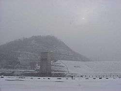 Fishtrap Lake and dam during a winter storm | |
| Location | Pike County, Kentucky |
| Coordinates | 37°25′55″N 82°24′55″W / 37.43194°N 82.41528°WCoordinates: 37°25′55″N 82°24′55″W / 37.43194°N 82.41528°W |
| Type | reservoir |
| Primary inflows | Levisa Fork of the Big Sandy River |
| Primary outflows | Levisa Fork of the Big Sandy River |
| Basin countries | United States |
| Surface area | 1,130-acre (5 km2) |
| Surface elevation | 757 feet (231 m) |
Fishtrap Lake is a 1,130-acre (5 km2) reservoir in Pike County, Kentucky. Dedicated by President Lyndon B. Johnson in 1968, the lake was formed by the impounding of the Levisa Fork of the Big Sandy River at the 195-foot-high Fishtrap Dam (37°25′55″N 82°24′55″W / 37.43194°N 82.41528°W) by the United States Army Corps of Engineers.[1]
It is the primary attraction of Fishtrap Lake State Park.[2]
References
- ↑ Kleber, John E., ed. (1992). "Lakes". The Kentucky Encyclopedia. Associate editors: Thomas D. Clark, Lowell H. Harrison, and James C. Klotter. Lexington, Kentucky: The University Press of Kentucky. ISBN 0-8131-1772-0.
- ↑ "Fishtrap Lake State Park". Kentucky Department of Parks. 2005-10-10. Retrieved 2007-02-17.
External links
- Fishtrap Lake - U.S. Army Corps of Engineers
- "Fishtrap Lake". Geographic Names Information System. United States Geological Survey. Retrieved 2009-05-04.
- Fishtrap Lake facilities map


This article is issued from
Wikipedia.
The text is licensed under Creative Commons - Attribution - Sharealike.
Additional terms may apply for the media files.