Fisher Peak (Washington)
| Fisher Peak | |
|---|---|
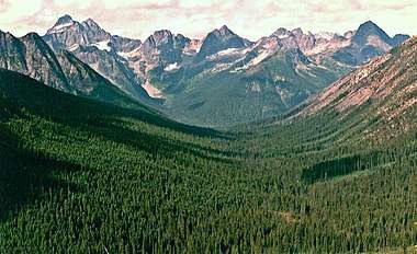
 Fisher Peak seen from the North Cascades Highway | |
| Highest point | |
| Elevation | 8,040 ft (2,451 m) [1] |
| Prominence | 720 ft (220 m) [1] |
| Isolation | 1.02 mi (1.64 km) [1] |
| Coordinates | 48°32′43″N 120°49′26″W / 48.54528°N 120.82389°WCoordinates: 48°32′43″N 120°49′26″W / 48.54528°N 120.82389°W [1] |
| Geography | |
 Fisher Peak Location of Fisher Peak in Washington | |
| Location | Border of Chelan and Skagit Counties, Washington, United States |
| Parent range | North Cascades |
| Topo map | USGS Mount Arriva |
| Climbing | |
| First ascent | 1940, Fred Beckey, Jim Crooks, Ed Kennedy[2] |
| Easiest route | Scrambling |
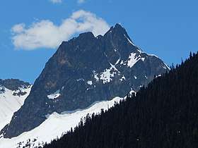
Fisher Peak is a summit in the Cascade Range in the U.S. state of Washington. It is located on the borders of the Stephen Mather Wilderness and North Cascades National Park. It's situated midway between Black Peak and Easy Pass, adjacent to Repulse Peak. Precipitation runoff from Fisher Peak drains into tributaries of the Skagit River.
Climate
Fisher Peak is located in the marine west coast climate zone of western North America.[2] Most weather fronts originate in the Pacific Ocean, and travel northeast toward the Cascade Mountains. As fronts approach the North Cascades, they are forced upward by the peaks of the Cascade Range (Orographic lift), causing them to drop their moisture in the form of rain or snowfall onto the Cascades. As a result, the west side of the North Cascades experiences high precipitation, especially during the winter months in the form of snowfall. During winter months, weather is usually cloudy, but, due to high pressure systems over the Pacific Ocean that intensify during summer months, there is often little or no cloud cover during the summer.[3] Because of maritime influence, snow tends to be wet and heavy, resulting in high avalanche danger.[3]
References
- 1 2 3 4 "Fisher Peak, Washington". Peakbagger.com.
- 1 2 Beckey, Fred W. (2009). Cascade Alpine Guide: climbing and high routes, Vol. 3, Rainy Pass to Fraser River (3rd ed.). Mountaineers Books. p. 302. ISBN 978-1-59485-136-0.
- 1 2 Beckey, p. 16