Black Peak (Washington)
| Black Peak | |
|---|---|
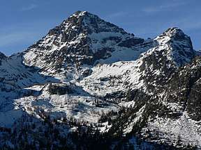 Black Peak, Washington, looking west-northwest | |
| Highest point | |
| Elevation | 8,975 ft (2,736 m) [1] NAVD 88 |
| Prominence | 3,450 ft (1,050 m) [1] |
| Isolation | 5.2 mi (8.4 km) [1] |
| Coordinates | 48°31′25″N 120°48′58″W / 48.52361°N 120.81611°WCoordinates: 48°31′25″N 120°48′58″W / 48.52361°N 120.81611°W [1] |
| Geography | |
 Black Peak Location of Black Peak in Washington | |
| Location | Border of Chelan and Skagit Counties, Washington, United States[2] |
| Parent range | Cascade Range |
| Topo map | USGS Mount Arriva quadrangle [2] |
Black Peak is a tall peak in the Cascade Range in the U.S. state of Washington. It lies in the Stephen Mather Wilderness and North Cascades National Park. At 8,975 feet (2,736 m) in elevation it is the 20th-highest peak in Washington.[1] Black Peaks's prominence is 3,450 feet (1,050 m), making it the 35th-most prominent peak in Washington. The nearest higher peak is Goode Mountain, 5.2 miles (8.4 km) to the west-southwest.[1]
Black Peak is a non-volcanic mountain and is popular among hikers and campers worldwide.[3]
See also
References
- 1 2 3 4 5 6 "Black Peak, Washington". Peakbagger.com. Retrieved 2014-08-18.
- 1 2 "Black Peak". Geographic Names Information System. United States Geological Survey. 1979-09-10. Retrieved 2014-08-18.
- ↑ "Black Peak". Summit Post. Retrieved 2015-05-27.
External links
- "Black Peak". SummitPost.org. Retrieved 2014-08-18.
- "Black Peak". PEAKWARE World Mountain Encyclopedia. Interactive Outdoors. Retrieved 2014-08-18.
This article is issued from
Wikipedia.
The text is licensed under Creative Commons - Attribution - Sharealike.
Additional terms may apply for the media files.