Fincastle, Tennessee
| Fincastle, Tennessee | |
|---|---|
| Census-designated place | |
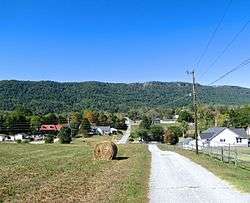 Houses in Fincastle | |
 Fincastle, Tennessee | |
| Coordinates: 36°24′35″N 84°02′52″W / 36.40972°N 84.04778°WCoordinates: 36°24′35″N 84°02′52″W / 36.40972°N 84.04778°W | |
| Country | United States |
| State | Tennessee |
| County | Campbell |
| Area[1] | |
| • Total | 3.653 sq mi (9.46 km2) |
| • Land | 3.653 sq mi (9.46 km2) |
| • Water | 0 sq mi (0 km2) |
| Elevation | 1,129 ft (344 m) |
| Population (2010)[2] | |
| • Total | 1,618 |
| • Density | 440/sq mi (170/km2) |
| Time zone | UTC-5 (Eastern (EST)) |
| • Summer (DST) | UTC-4 (EDT) |
| Area code(s) | 423 |
| GNIS feature ID | 1284257[3] |
Fincastle is a census-designated place and unincorporated community in Campbell County, Tennessee, United States. Its population was 1,618 as of the 2010 census.[2]
Once known as Glade Springs, Fincastle was later named for Fincastle, Virginia, which was the original home of many of its early settlers.[4]
Geography
Fincastle is located along State Route 63 northeast of LaFollette and southwest of Speedwell in the Powell Valley. Cumberland Mountain rises prominently to the north, and Norris Lake lies a few miles to the south.
References
- ↑ "US Gazetteer files: 2010, 2000, and 1990". United States Census Bureau. 2011-02-12. Retrieved 2011-04-23.
- 1 2 "American FactFinder". United States Census Bureau. Archived from the original on 2013-09-11. Retrieved 2011-05-14.
- ↑ "Fincastle". Geographic Names Information System. United States Geological Survey.
- ↑ Larry Miller, Tennessee Place Names (Indiana University Press, 2001), p. 76.
External links

Municipalities and communities of Campbell County, Tennessee, United States | ||
|---|---|---|
| Cities | ||
| Towns | ||
| CDP | ||
| Unincorporated communities | ||
| Footnotes | ‡ This populated place also has portions in an adjacent county or counties | |
This article is issued from
Wikipedia.
The text is licensed under Creative Commons - Attribution - Sharealike.
Additional terms may apply for the media files.