Fimber
| Fimber | |
|---|---|
 Fimber Fimber shown within the East Riding of Yorkshire | |
| Population | 91 (2001 census)[1] |
| OS grid reference | SE895606 |
| • London | 175 mi (282 km) S |
| Civil parish |
|
| Unitary authority | |
| Ceremonial county | |
| Region | |
| Country | England |
| Sovereign state | United Kingdom |
| Post town | DRIFFIELD |
| Postcode district | YO25 |
| Dialling code | 01377 |
| Police | Humberside |
| Fire | Humberside |
| Ambulance | Yorkshire |
| EU Parliament | Yorkshire and the Humber |
| UK Parliament | |
Fimber is a village and civil parish in the East Riding of Yorkshire, England. It is situated approximately 8 miles (13 km) north-west of Driffield town centre and 3 miles (5 km) south-west of the village of Sledmere. It lies on the B1248 road.
The civil parish is formed by the village of Fimber and the hamlet of Towthorpe. According to the 2001 UK Census, Fimber parish had a population of 91.[1]
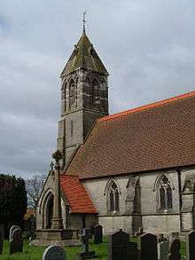
The church of St Mary, Fimber was built in 1869–71 in a thirteenth-century style to replace a chapel of ease. The church was designated a Grade II listed building in September 1966 and is now recorded in the National Heritage List for England, maintained by Historic England.[2] It is on the Sykes Churches Trail devised by the East Yorkshire Churches Group.[3]
Fimber was served by Sledmere and Fimber railway station on the Malton and Driffield Railway between 1853 and 1950.[4]
In 1823 the village was in the parish of Wetwang, the Wapentake of Buckrose, and the Liberty of St Peter. At the time there was a chapel of ease at which the rector of Wetwang was its incumbent curate. Population was 904, which included seven farmers, a grocer, a shoemaker, and a tailor.[5]
References
- 1 2 "2001 Census: Area Profiles - Fimber" (PDF). East Riding of Yorkshire Council. Archived (PDF) from the original on 12 February 2012. Retrieved 8 February 2013.
- ↑ Historic England. "Church of St Mary (1083790)". National Heritage List for England. Retrieved 29 April 2013.
- ↑ "Sykes Churches Trail Southern Route". Beverley, East Yorkshire: East Yorkshire Historic Churches Group.
- ↑ Butt, R. V. J. (1995). The Directory of Railway Stations: details every public and private passenger station, halt, platform and stopping place, past and present (1st ed.). Sparkford: Patrick Stephens Ltd. ISBN 978-1-85260-508-7. OCLC 60251199.
- ↑ Baines, Edward (1823): History, Directory and Gazetteer of the County of York, p. 204
- Gazetteer — A–Z of Towns Villages and Hamlets. East Riding of Yorkshire Council. 2006. p. 5.
| Wikimedia Commons has media related to Fimber. |