Ficulle
| Ficulle | |
|---|---|
| Comune | |
| Comune di Ficulle | |
 | |
 Ficulle Location of Ficulle in Italy | |
| Coordinates: 42°50′N 12°4′E / 42.833°N 12.067°ECoordinates: 42°50′N 12°4′E / 42.833°N 12.067°E | |
| Country | Italy |
| Region | Umbria |
| Province | Terni (TR) |
| Government | |
| • Mayor | Gianluigi Maravalle |
| Area | |
| • Total | 64.62 km2 (24.95 sq mi) |
| Elevation | 437 m (1,434 ft) |
| Population (31 July 2017)[1] | |
| • Total | 1,654 |
| • Density | 26/km2 (66/sq mi) |
| Demonym(s) | Ficullesi |
| Time zone | UTC+1 (CET) |
| • Summer (DST) | UTC+2 (CEST) |
| Postal code | 05016 |
| Dialing code | 0763 |
| Website | Official website |
Ficulle is a comune (municipality) in the Province of Terni in the Italian region Umbria, located about 40 km southwest of Perugia and about 60 km northwest of Terni.
Ficulle borders the following municipalities: Allerona, Fabro, Montegabbione, Orvieto, Parrano, San Venanzo.
History
The origins of the town and the castle date back to the 11th century even though it is supposed to have been born in the beginning as a trading station of the Roman Empire. Because of the excellent territorial position, in the Middle Ages Ficulle was contended by two noble families: Monaldeschi and Filippeschi, both from Orvieto. It suffered their struggles until 1416 AD, when the town passed under control of the Papal States.
Main sights
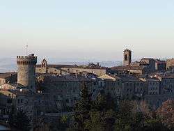
- Walls and Rocca (fortress)
- Castello della Sala, founded in 1350
- Medieval borough
- Church of Santa Maria Vecchia (early 13th century)
- Abbey of S. Niccolò al Monte Orvietano
- Sanctuary of Madonna della Maestà
References
External links

This article is issued from
Wikipedia.
The text is licensed under Creative Commons - Attribution - Sharealike.
Additional terms may apply for the media files.