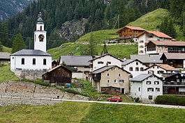
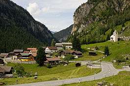
Ferrera
| Ferrera | ||
|---|---|---|
 | ||
| ||
 Ferrera | ||
|
Location of Ferrera 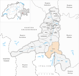 Ferrera Ferrera (Canton of Graubünden) | ||
| Coordinates: 46°33′N 9°26′E / 46.550°N 9.433°ECoordinates: 46°33′N 9°26′E / 46.550°N 9.433°E | ||
| Country | Switzerland | |
| Canton | Graubünden | |
| District | Viamala | |
| Area[1] | ||
| • Total | 75.46 km2 (29.14 sq mi) | |
| Elevation | 1,316 m (4,318 ft) | |
| Population (Dec 2016[2]) | ||
| • Total | 79 | |
| • Density | 1.0/km2 (2.7/sq mi) | |
| Postal code | 7444 | |
| SFOS number | 3713 | |
| Localities | Innerferrera, Ausserferrera | |
| Surrounded by | Andeer, Avers, Madesimo (IT-SO), Mulegns, Piuro (IT-SO), Pignia, Riom-Parsonz, Salouf, Sufers | |
| Website |
www SFSO statistics | |

Ferrera is a municipality in the Viamala Region in the Grisons, Switzerland. It was formed on 1 January 2008 through the merger of Innerferrera and Ausserferrera. Geographically, it covers the entire Val Ferrera valley.
Historical population
The combined historical population of the two municipalities is given in the following table:[3][4]
| year | population |
|---|---|
| 1808 | 167 |
| 1850 | 273 |
| 1900 | 162 |
| 1950 | 145 |
| 1960 | 405a |
| 2000 | 96 |
- ^a Population increase due to construction of the dam at Valle di Lei
Languages
| Languages in Ferrera | ||||||
| Languages | Census of 1980 | Census of 1990 | Census of 2000 | |||
| Number | Percentage | Number | Percentage | Number | Percentage | |
| German | 79 | 69.30% | 75 | 75.76% | 90 | 91.84% |
| Romansh | 33 | 28.95% | 21 | 21.21% | 1 | 1.02% |
| Italian | 0 | 0.00% | 2 | 2.02% | 3 | 3.37% |
| Population | 114 | 100% | 99 | 100% | 98 | 100% |
| Languages in Ausserferrera | ||||||
| Languages | Census of 1980 | Census of 1990 | Census of 2000 | |||
| Number | Percentage | Number | Percentage | Number | Percentage | |
| German | 29 | 58.00% | 28 | 58.33% | 44 | 93.62% |
| Romansh | 19 | 38.00% | 17 | 35.42% | 1 | 2.13% |
| Italian | 0 | 0.00% | 2 | 4.17% | 1 | 2.13% |
| Population | 50 | 100% | 48 | 100% | 47 | 100% |
| Languages in Innerferrera | ||||||
| Languages | Census of 1980 | Census of 1990 | Census of 2000 | |||
| Number | Percentage | Number | Percentage | Number | Percentage | |
| German | 50 | 78.13% | 47 | 92.16% | 46 | 94.0% |
| Romansh | 14 | 21.88% | 4 | 7.84% | 2 | 6.0% |
| Population | 64 | 100% | 51 | 100% | 49 | 100% |
Weather
Innerferrera village in Ferrera has an average of 118.2 days of rain per year and on average receives 1,238 mm (48.7 in) of precipitation. The wettest month is August during which time Innerferrera receives an average of 158 mm (6.2 in) of precipitation. During this month there is precipitation for an average of 12.2 days. The month with the most days of precipitation is May, with an average of 13.3, but with only 141 mm (5.6 in) of precipitation. The driest month of the year is February with an average of 44 mm (1.7 in) of precipitation over 12.2 days.[5]
References
- ↑ Arealstatistik Standard - Gemeindedaten nach 4 Hauptbereichen
- ↑ Swiss Federal Statistical Office - STAT-TAB, online database – Ständige und nichtständige Wohnbevölkerung nach institutionellen Gliederungen, Geburtsort und Staatsangehörigkeit (in German) accessed 30 August 2017
- ↑ Ausserferrera in German, French and Italian in the online Historical Dictionary of Switzerland.
- ↑ Innerferrera in German, French and Italian in the online Historical Dictionary of Switzerland.
- ↑ "Temperature and Precipitation Average Values-Table, 1961-1990" (in German, French, and Italian). Federal Office of Meteorology and Climatology - MeteoSwiss. Archived from the original on 27 June 2009. Retrieved 8 May 2009. , the weather station elevation is 1475 meters above sea level.
External links
![]()
- Official Web site
- Jürg Simonett: Ausserferrera in Romansh, German, French and Italian in the online Historical Dictionary of Switzerland, 2005-02-11.
- Jürg Simonett: Innerferrera in Romansh, German, French and Italian in the online Historical Dictionary of Switzerland, 2007-01-19.