Fernleaf, Kentucky
| Fernleaf, Kentucky | |
|---|---|
| Unincorporated community | |
 Fernleaf, Kentucky Location within the state of Kentucky  Fernleaf, Kentucky Fernleaf, Kentucky (the US) | |
| Coordinates: 38°39′22″N 83°54′48″W / 38.65611°N 83.91333°WCoordinates: 38°39′22″N 83°54′48″W / 38.65611°N 83.91333°W | |
| Country | United States |
| State | Kentucky |
| County | Mason |
| Elevation | 945 ft (288 m) |
| Time zone | UTC-5 (Eastern (EST)) |
| • Summer (DST) | UTC-4 (EST) |
| Area code(s) | 606 |
| GNIS feature ID | 507992[1] |
Fernleaf is an unincorporated community in Mason County, Kentucky, United States.
Notes
Municipalities and communities of Mason County, Kentucky, United States | ||
|---|---|---|
| Cities | 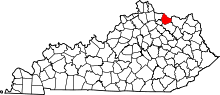 | |
| CDP | ||
| Other unincorporated communities | ||
| Footnotes | ‡This populated place also has portions in an adjacent county or counties | |
This article is issued from
Wikipedia.
The text is licensed under Creative Commons - Attribution - Sharealike.
Additional terms may apply for the media files.