Fergana Range
| Fergana Range | |
|---|---|
|
Kyrgyz: Фергана тоо кыркасы | |
 | |
| Highest point | |
| Elevation | 4,893 m (16,053 ft) |
| Dimensions | |
| Length | 206 km (128 mi) NW-SE [1] |
| Width | 62 km (39 mi) NE-SW [1] |
| Geography | |
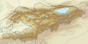 | |
| Country | Kyrgyzstan |
| State/Province | Naryn Region, Osh Region, Jalal-Abad Region |
| Range coordinates | 41°0.25′N 73°56.25′E / 41.00417°N 73.93750°ECoordinates: 41°0.25′N 73°56.25′E / 41.00417°N 73.93750°E |
| Geology | |
| Type of rock |
Composed of sandstones, limestones, and schists |
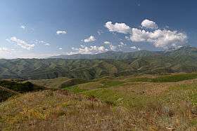
The Fergana Range (Kyrgyz: Фергана тоо кыркасы, Ferğana tó qırqası/Fergana too kyrkasy, فەرعانا توو قىرقاسى), also known as Ferganskiy Khrebet (Феранский Хребет) Ferganskij Hrebet in Russian, meaning “Ferghana Mountain” in English)[2] is a mountain range of the Tian Shan in the Kyrgyz Republic.[3] The length of the range is 206 km, and the average height is 3600 m above sea level. The highest Mountain is 4893 m ASL.[1]
Geography
The Fergana Range stretches from north-west to south-east, separating the Fergana Valley and the inner Tian Shan. The south-east section of the range is higher. It joins the Torugart Ridge and the Alaykuu Ridge via the Seok Pass. The South-west slope is long and low-sloped, the north-east - short and steep.
Geology
The Fergana Range is composed of schist, sandstone, limestone, and other sedimentary metamorphic formations ruptured by intrusions of gabbro and diabase.
References
- 1 2 3 Атлас Кыргызской Республики [Atlas of Kyrgyz Republic] (in Russian). Bishkek: Academy of Sciences of Kyrgyz SSR. 1987. p. 156.
- ↑ geoview.info
- ↑ Great Soviet Encyclopedia, on-line edition, in Russian.